IMAGES TAKEN NEAR TO
Dukes Road, DORKING, RH5 5BY
Introduction
This page details the photographs taken nearby to Dukes Road, RH5 5BY by members of the Geograph project.
The Geograph project started in 2005 with the aim of publishing, organising and preserving representative images for every square kilometre of Great Britain, Ireland and the Isle of Man.

There are currently over 7.5m images from over14,400 individuals and you can help contribute to the project by visiting https://www.geograph.org.uk
Image Map
Images are licensed for reuse under creativecommons.org/licenses/by-sa/2.0
Notes
- Clicking on the map will re-center to the selected point.
- The higher the marker number, the further away the image location is from the centre of the postcode.
Image Listing (23 Images Found)
Images are licensed for reuse under creativecommons.org/licenses/by-sa/2.0
Image
Details
Distance
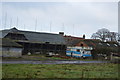
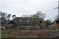
1
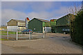
Poultry sheds, Home Farm
The title says poultry sheds, since that's what they appear to be from the outside. But an internet search suggests that they now house a number of small businesses, including a scaffolding firm.
Image: © Ian Capper
Taken: 17 Apr 2010
0.02 miles
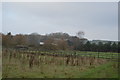
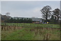
7
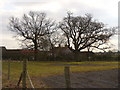
Oaks at Home Farm
In the Surrey Weald south-east of Newdigate.
Image: © Colin Smith
Taken: 13 Mar 2010
0.10 miles
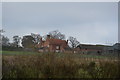
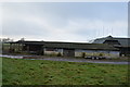
10
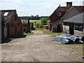
Home Farm
Some of these buildings seem to be in a ruinous condition.
Image: © Dr Neil Clifton
Taken: 24 Jun 2015
0.12 miles