IMAGES TAKEN NEAR TO
Dukes Road, DORKING, RH5 5BS
Introduction
This page details the photographs taken nearby to Dukes Road, RH5 5BS by members of the Geograph project.
The Geograph project started in 2005 with the aim of publishing, organising and preserving representative images for every square kilometre of Great Britain, Ireland and the Isle of Man.

There are currently over 7.5m images from over14,400 individuals and you can help contribute to the project by visiting https://www.geograph.org.uk
Image Map
Images are licensed for reuse under creativecommons.org/licenses/by-sa/2.0
Notes
- Clicking on the map will re-center to the selected point.
- The higher the marker number, the further away the image location is from the centre of the postcode.
Image Listing (29 Images Found)
Images are licensed for reuse under creativecommons.org/licenses/by-sa/2.0
Image
Details
Distance
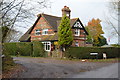
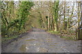
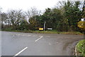
1
East Lodge
Where Duke's Road meets Partridge Lane. Presumably a former lodge of Newdigate Place.
Image: © Ian Capper
Taken: 17 Apr 2010
0.00 miles
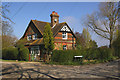
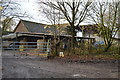
2
House, corner of Duke's Drive and Partridge Lane
Image: © N Chadwick
Taken: 30 Nov 2014
0.00 miles
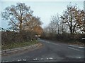
3
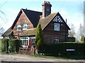
East Lodge
Looking north-west at the junction of Dukes Road with Partridge Lane.
Image: © Andrew Longton
Taken: 6 Apr 2006
0.03 miles
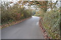
5
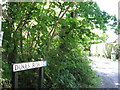
Dukes Road and bridleway sign off Partridge Lane
Image: © Dave Spicer
Taken: 1 Aug 2013
0.05 miles
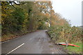
9
Charlwood Lane at the junction of Partridge Lane
Image: © David Howard
Taken: 4 Dec 2016
0.08 miles