IMAGES TAKEN NEAR TO
Burnt Oak Lane, DORKING, RH5 5BJ
Introduction
This page details the photographs taken nearby to Burnt Oak Lane, RH5 5BJ by members of the Geograph project.
The Geograph project started in 2005 with the aim of publishing, organising and preserving representative images for every square kilometre of Great Britain, Ireland and the Isle of Man.

There are currently over 7.5m images from over14,400 individuals and you can help contribute to the project by visiting https://www.geograph.org.uk
Image Map
Images are licensed for reuse under creativecommons.org/licenses/by-sa/2.0
Notes
- Clicking on the map will re-center to the selected point.
- The higher the marker number, the further away the image location is from the centre of the postcode.
Image Listing (7 Images Found)
Images are licensed for reuse under creativecommons.org/licenses/by-sa/2.0
Image
Details
Distance
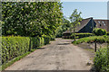
1
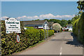
Cudworth Park
Park home site off Burnt Oak Lane.
Image: © Ian Capper
Taken: 20 May 2018
0.06 miles
2
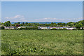
Cudworth Park
Park home site off Burnt Oak Lane. In the distance is Leith Hill.
Image: © Ian Capper
Taken: 20 May 2018
0.10 miles
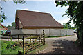
3
Barn being converted,Cudworth Manor Farm
A view from the south. For a reverse view see Image .
Image: © Robin Webster
Taken: 30 Jun 2010
0.15 miles
4
Barn being converted, Cudworth Manor Farm
A view from the north. For a reverse view, see Image
Image: © Robin Webster
Taken: 30 Jun 2010
0.16 miles
5
Cudworth Manor Farm
Farm at the junction of Burnt Oak Lane and Cudworth Lane.
Image: © Ian Capper
Taken: 20 May 2018
0.16 miles
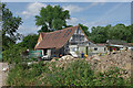
6

Cudworth manor house, Surrey
Cudworth is a small settlement hidden away in the depths of the Surrey countryside. The moated manor house dates from about 1500 but has been much altered and extended over the years.
Image: © Ron Strutt
Taken: 19 Feb 2005
0.21 miles
7
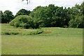
The Beam Brook
This takes a sinuous course here, doubling back to the right along the margin of the trees.
Image: © Robin Webster
Taken: 30 Jun 2010
0.22 miles