IMAGES TAKEN NEAR TO
Henfold Lane, DORKING, RH5 5AF
Introduction
This page details the photographs taken nearby to Henfold Lane, RH5 5AF by members of the Geograph project.
The Geograph project started in 2005 with the aim of publishing, organising and preserving representative images for every square kilometre of Great Britain, Ireland and the Isle of Man.

There are currently over 7.5m images from over14,400 individuals and you can help contribute to the project by visiting https://www.geograph.org.uk
Image Map
Images are licensed for reuse under creativecommons.org/licenses/by-sa/2.0
Notes
- Clicking on the map will re-center to the selected point.
- The higher the marker number, the further away the image location is from the centre of the postcode.
Image Listing (4 Images Found)
Images are licensed for reuse under creativecommons.org/licenses/by-sa/2.0
Image
Details
Distance
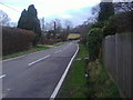
1
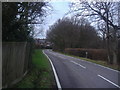
Henfold Lane, Newdigate
Looking towards Knowle cottages
Image: © David Howard
Taken: 30 Jan 2012
0.05 miles
3
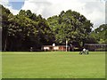
Rolling the square at Newdigate Cricket Club
The pavilion nestles under the trees in the north-west corner of the Brocus, at the edge of Knoll Copse.
Image: © Andy Potter
Taken: 24 Jul 2007
0.18 miles
4
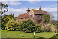
Brooklag Farm
Farmhouse at the junction of Henfold Lane and Parkgate Road.
Image: © Ian Capper
Taken: 6 Apr 2013
0.23 miles