IMAGES TAKEN NEAR TO
Henfold Lane, DORKING, RH5 4RW
Introduction
This page details the photographs taken nearby to Henfold Lane, RH5 4RW by members of the Geograph project.
The Geograph project started in 2005 with the aim of publishing, organising and preserving representative images for every square kilometre of Great Britain, Ireland and the Isle of Man.

There are currently over 7.5m images from over14,400 individuals and you can help contribute to the project by visiting https://www.geograph.org.uk
Image Map
Images are licensed for reuse under creativecommons.org/licenses/by-sa/2.0
Notes
- Clicking on the map will re-center to the selected point.
- The higher the marker number, the further away the image location is from the centre of the postcode.
Image Listing (10 Images Found)
Images are licensed for reuse under creativecommons.org/licenses/by-sa/2.0
Image
Details
Distance
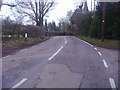
2
Henfold Lane, steep hill 17%
A pre-Worboys sign is next to this point under the modern hill sign, saying 'low gear now'.
Image: © David Howard
Taken: 30 Jan 2012
0.03 miles
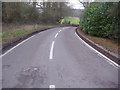
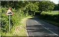
3
Henfold Lane - Steep Hill 17%
Henfold Lane, Newdigate. 17% steep hill down sign.
Image: © Adam Morse
Taken: 12 Jul 2009
0.03 miles
4
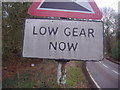
Pre-Worboys low gear sign, Henfold Lane
Using transfer letters, as you would expect, they are now wearing away after at least 50 years doing a fine job and continuing to do so. The sign above would have been a hill with a red triangle above, but they have left one part at least as it fulfils the function perfectly as it is.
Image: © David Howard
Taken: 30 Jan 2012
0.04 miles
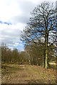
5

Looking across bridleway 581, Capel
The more geometric trees are in the grounds of Derry Stud.
Image: © Robin Webster
Taken: 15 Mar 2011
0.12 miles
6
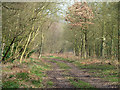
The way to the woods
A track through a belt of trees heads towards a complex of variously named copses together forming quite a large wood.
Image: © Robin Webster
Taken: 15 Mar 2011
0.12 miles
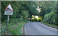
7
Henfold Lane - Steep Hill 17%
Henfold Lane, Newdigate. 17% steep hill up sign.
Image: © Adam Morse
Taken: 12 Jul 2009
0.14 miles
8
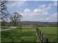
Leith Hill from Henfold Farm
Looking west, Leith Hill dominates the view from Henfold stud farm.
Image: © Thomas Grant
Taken: 17 Mar 2004
0.16 miles
9
Well Copse
Bridleway leading from Parkgate Road to Henfold Lane.
Image: © Ian Capper
Taken: 6 Apr 2013
0.20 miles
10
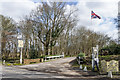
Henfold Lakes
Entrance to Henfold Lakes coarse fishing site off Henfold Lane.
Image: © Ian Capper
Taken: 6 Apr 2013
0.24 miles