IMAGES TAKEN NEAR TO
Horsham Road, DORKING, RH5 4QR
Introduction
This page details the photographs taken nearby to Horsham Road, RH5 4QR by members of the Geograph project.
The Geograph project started in 2005 with the aim of publishing, organising and preserving representative images for every square kilometre of Great Britain, Ireland and the Isle of Man.

There are currently over 7.5m images from over14,400 individuals and you can help contribute to the project by visiting https://www.geograph.org.uk
Image Map
Images are licensed for reuse under creativecommons.org/licenses/by-sa/2.0
Notes
- Clicking on the map will re-center to the selected point.
- The higher the marker number, the further away the image location is from the centre of the postcode.
Image Listing (16 Images Found)
Images are licensed for reuse under creativecommons.org/licenses/by-sa/2.0
Image
Details
Distance
1
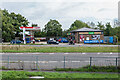
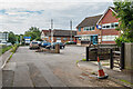
Beare Green Service Station
Esso filling station on the A24 in Beare Green.
Image: © Ian Capper
Taken: 4 Sep 2020
0.05 miles
2
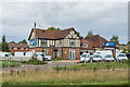
Hadleigh
c1930s house on the A24 Horsham Road, now housing a garage selling commercial vehicles, Priority Commercials Ltd.
Image: © Ian Capper
Taken: 4 Sep 2020
0.07 miles
3
Van sales at Holmwood
The A24 dual carriageway is in the foreground.
Image: © Dave Spicer
Taken: 11 Aug 2013
0.09 miles
4
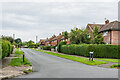
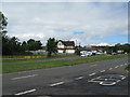
Leith Road
Mid 20th Century housing in Beare Green. Development of this area had commenced in the late 1930s but was halted by the Second World War.
Image: © Ian Capper
Taken: 4 Sep 2020
0.10 miles
5
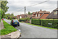
Leith Road
Mid 20th Century housing in Beare Green. Development of this area had commenced in the late 1930s but was halted by the Second World War.
Image: © Ian Capper
Taken: 4 Sep 2020
0.10 miles
6
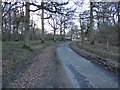
Old Horsham Road
Various businesses on Old Horsham Road, with the A24 Beare Green bypass, which superseded it, on the left.
Image: © Ian Capper
Taken: 4 Sep 2020
0.11 miles
7

Leith Road
Mid 20th Century housing in Beare Green. Development of this area had commenced in the late 1930s but was halted by the Second World War.
Image: © Ian Capper
Taken: 4 Sep 2020
0.11 miles
8
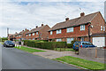
Springwell Road
Mid 20th Century housing in Beare Green. Development of this area had commenced in the late 1930s but was halted by the Second World War.
Image: © Ian Capper
Taken: 4 Sep 2020
0.12 miles
9

The Duke's Head
Pub on the A24 Horsham Road, with records back to at least 1822.
Image: © Ian Capper
Taken: 4 Sep 2020
0.16 miles