IMAGES TAKEN NEAR TO
Henfold Lane, DORKING, RH5 4NX
Introduction
This page details the photographs taken nearby to Henfold Lane, RH5 4NX by members of the Geograph project.
The Geograph project started in 2005 with the aim of publishing, organising and preserving representative images for every square kilometre of Great Britain, Ireland and the Isle of Man.

There are currently over 7.5m images from over14,400 individuals and you can help contribute to the project by visiting https://www.geograph.org.uk
Image Map
Images are licensed for reuse under creativecommons.org/licenses/by-sa/2.0
Notes
- Clicking on the map will re-center to the selected point.
- The higher the marker number, the further away the image location is from the centre of the postcode.
Image Listing (24 Images Found)
Images are licensed for reuse under creativecommons.org/licenses/by-sa/2.0
Image
Details
Distance
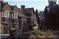
2
Henfold Lane
Part of the back road linking Dorking with Newdigate. The building in the background is Posterns Court.
Image: © Ian Capper
Taken: 6 Apr 2013
0.06 miles
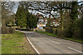
3
Henfold Lane, Holmwood
The portrait version
Image: © David Howard
Taken: 30 Jan 2012
0.08 miles
5
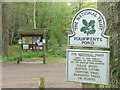
Fourwents Pond
NT-owned pond at the south-east corner of Holmwood Common in the Surrey Weald. Two large car parks and a covered information board cater for visitors.
http://www.nationaltrust.org.uk/main/w-global/w-localtoyou/w-south_east/w-south_east-countryside/w-south_east-places-north_downs/w-south_east-places-north_downs-holmwood_common.htm
Image: © Colin Smith
Taken: 18 Apr 2011
0.16 miles
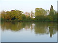
6
Fourwents Pond
Large pond and car park at the south-east corner of Holmwood Common.
http://www.nationaltrust.org.uk/main/w-global/w-localtoyou/w-south_east/w-south_east-countryside/w-south_east-places-north_downs/w-south_east-places-north_downs-holmwood_common.htm
Image: © Colin Smith
Taken: 18 Apr 2011
0.17 miles
7
Fourwents Pond
Large Pond with two car parks nearby, ideal for exploring the adjacent Holmwood Common.
http://www.nationaltrust.org.uk/main/w-global/w-localtoyou/w-south_east/w-south_east-countryside/w-south_east-places-north_downs/w-south_east-places-north_downs-holmwood_common.htm
Image: © Colin Smith
Taken: 18 Apr 2011
0.17 miles
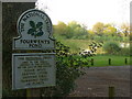
8
Fourwents Pond, Holmwood Common (2)
The name refers to the cross-roads nearby - see: Image
Image: © Stefan Czapski
Taken: 1 Nov 2012
0.18 miles
9
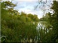
Fourwents Pond, Holmwood Common (3)
A biggish pond on Holmwood Common. Largely surrounded by woodland, but lying in the angle of roads which converge at a cross-roads, hence the name 'Four Wents': http://www.geograph.org.uk/photo/3207754
Image: © Stefan Czapski
Taken: 1 Nov 2012
0.18 miles
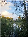
10
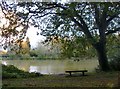
Fourwents Pond, Holmwood Common (1)
After heavy rain in the previous few days, the pond was muddy - the water a greenish yellow, almost the colour of lentil soup.
The name 'Fourwents' interests me. An old friend of mine, who farmed at Cliffe in Kent, would refer to a T-junction as a 'three-went way'. There are various 'Three Wents' or 'Four Wents' to be found across the map of south-east England - though I don't know of that many. Fourwents Pond lies close to a busy cross-roads - and isn't as remote as the photo might suggest.
The area is in the hands of the National Trust.
Image: © Stefan Czapski
Taken: 1 Nov 2012
0.18 miles