IMAGES TAKEN NEAR TO
Folly Lane, Horsham Road, DORKING, RH5 4NQ
Introduction
This page details the photographs taken nearby to Folly Lane, Horsham Road, RH5 4NQ by members of the Geograph project.
The Geograph project started in 2005 with the aim of publishing, organising and preserving representative images for every square kilometre of Great Britain, Ireland and the Isle of Man.

There are currently over 7.5m images from over14,400 individuals and you can help contribute to the project by visiting https://www.geograph.org.uk
Image Map
Images are licensed for reuse under creativecommons.org/licenses/by-sa/2.0
Notes
- Clicking on the map will re-center to the selected point.
- The higher the marker number, the further away the image location is from the centre of the postcode.
Image Listing (42 Images Found)
Images are licensed for reuse under creativecommons.org/licenses/by-sa/2.0
Image
Details
Distance
1
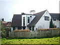
The Sundial
Built in 1903 on the site of two ancient cottages to a design by Arnold Dunbar Smith for Mr and Mrs Pethick Lawrence http://en.wikipedia.org/wiki/Pethick_Lawrence as a country home for Emmeline Pethick Lawrence’s Esperance club for working class London girls. It was subsequently owned/occupied by author and journalist John Langdon-Davies http://en.wikipedia.org/wiki/John_Langdon-Davies , founder of PLAN http://en.wikipedia.org/wiki/Plan_(aid_organisation). A sundial reading the motto, ‘Let others tell of storms and showers, I tell of sunny morning hours’ is on the south-east facing wall.
Image: © Andy Potter
Taken: 24 Mar 2009
0.05 miles
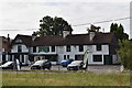
4
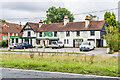
The Holly & Laurel Emporium
Craft and furniture store on the A24, housed in what was originally a pub, named the Sawyers Arms on the 1870-80 1:2,500 map and the Holly and Laurel on the 1896, 1914 and 1972 editions.
Image: © Ian Capper
Taken: 4 Sep 2020
0.08 miles
5

The Dorking Stove and Fireplace Emporium
Something of a feature of the A24 at Holmwood the sign over the door says "The Holly & Laurel Emporium". Suppliers of "new and reclaimed Stoves, Fireplaces, Gas Fires, Accessories and Flue Pipes" "together with a wide range of landscape furniture and other items of Architectural Salvage". See their website http://www.dorkingstoves.com for more information. Previously the Laurel and Holly Hotel it also looks a likely candidate for the Sawyers Arms, marked on the 1873 map.
Image: © Andy Potter
Taken: 24 Mar 2009
0.08 miles
8
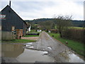
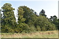
Folly Lane, looking towards Redlands Wood
Folly Lane is a backwater, close to the busy A24 dual carriageway. From this direction, with the road 100 yards behind the camera, Redlands Wood a Forestry Commission plantation can be seen in the distance.
Image: © Pip Rolls
Taken: 17 Jan 2006
0.09 miles
9
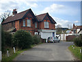
Former butcher's shop
The sign over the window has been painted over but the name J. Davies can still be made out. When the shop was still open there was a full-sized fibre-glass figure of a butcher which stood at the side of the A24 - it wore a boater and apron. I believe that this may have always been a butcher's shop - it was during the Second World War http://www.bbc.co.uk/ww2peopleswar/stories/10/a1982810.shtml.
Image: © Andy Potter
Taken: 24 Mar 2009
0.10 miles
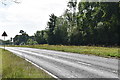
10
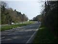
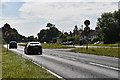
Alfred Gwynne Vanderbilt's favourite road
The London to Worthing Road (A24) looking south from Image
Image: © Andy Potter
Taken: 24 Mar 2009
0.11 miles