IMAGES TAKEN NEAR TO
Anstie Lane, DORKING, RH5 4LL
Introduction
This page details the photographs taken nearby to Anstie Lane, RH5 4LL by members of the Geograph project.
The Geograph project started in 2005 with the aim of publishing, organising and preserving representative images for every square kilometre of Great Britain, Ireland and the Isle of Man.

There are currently over 7.5m images from over14,400 individuals and you can help contribute to the project by visiting https://www.geograph.org.uk
Image Map
Images are licensed for reuse under creativecommons.org/licenses/by-sa/2.0
Notes
- Clicking on the map will re-center to the selected point.
- The higher the marker number, the further away the image location is from the centre of the postcode.
Image Listing (34 Images Found)
Images are licensed for reuse under creativecommons.org/licenses/by-sa/2.0
Image
Details
Distance
2
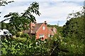
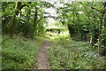
Moorhurst Lane at Anstie Lane
At this end of Moorhurst Lane it is just a track.
Image: © Robert Eva
Taken: 24 Oct 2017
0.03 miles
4

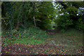
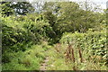
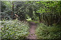
Spring on Anstie Lane
Snowdrops making an appearance by the lane verge near Minnickfold.
Image: © Colin Smith
Taken: 20 Feb 2011
0.04 miles
10
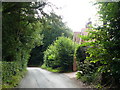
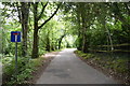
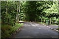
Anstie Lane, Coldharbour, Surrey
Looking back down the lane, which climbs steadily at this point.
Image: © Peter Trimming
Taken: 16 Jul 2009
0.08 miles