IMAGES TAKEN NEAR TO
Church Terrace, Betchetts Green Road, DORKING, RH5 4JZ
Introduction
This page details the photographs taken nearby to Church Terrace, Betchetts Green Road, RH5 4JZ by members of the Geograph project.
The Geograph project started in 2005 with the aim of publishing, organising and preserving representative images for every square kilometre of Great Britain, Ireland and the Isle of Man.

There are currently over 7.5m images from over14,400 individuals and you can help contribute to the project by visiting https://www.geograph.org.uk
Image Map
Images are licensed for reuse under creativecommons.org/licenses/by-sa/2.0
Notes
- Clicking on the map will re-center to the selected point.
- The higher the marker number, the further away the image location is from the centre of the postcode.
Image Listing (69 Images Found)
Images are licensed for reuse under creativecommons.org/licenses/by-sa/2.0
Image
Details
Distance
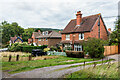
1
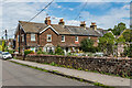
Church Terrace
Victorian terrace of 6 cottages off Norfolk Road.
Image: © Ian Capper
Taken: 4 Sep 2020
0.00 miles
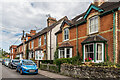
2
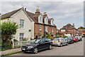
Norfolk Road
Mixed age housing in a road originally laid out in the late 19th Century - mapping suggests that the cottage on far left dates from around the turn of the 19th/20th Centuries.
Image: © Ian Capper
Taken: 4 Sep 2020
0.01 miles
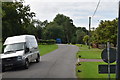
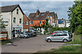
5
Tyre suppliers at South Holmwood
Alongside the A24.
Image: © Dave Spicer
Taken: 11 Aug 2013
0.04 miles
6
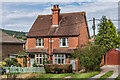
Forge Cottages
Semi-detached cottages in Betchets Green Road with a date plaque of 1904.
Image: © Ian Capper
Taken: 4 Sep 2020
0.04 miles
8
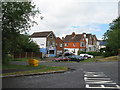
Horsham Road
Houses and businesses on Horsham Road. The nearest building, now an "Osteopath and Complementary Health Clinic", was once a post office.
Image: © Ian Capper
Taken: 4 Sep 2020
0.04 miles
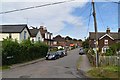
9
Betchets Green Road
Houses in Betchets Green Road. The nearest, Forge Cottages, has a date plaque of 1904.
Image: © Ian Capper
Taken: 4 Sep 2020
0.05 miles
10
Buckingham Road
A road originally laid out in the late 19th Century - mapping suggests that the buildings in this photo date from around the turn of the 19th/20th Centuries.
Image: © Ian Capper
Taken: 4 Sep 2020
0.05 miles