IMAGES TAKEN NEAR TO
Parklands, Hardy Close, DORKING, RH5 4HQ
Introduction
This page details the photographs taken nearby to Parklands, Hardy Close, RH5 4HQ by members of the Geograph project.
The Geograph project started in 2005 with the aim of publishing, organising and preserving representative images for every square kilometre of Great Britain, Ireland and the Isle of Man.

There are currently over 7.5m images from over14,400 individuals and you can help contribute to the project by visiting https://www.geograph.org.uk
Image Map
Images are licensed for reuse under creativecommons.org/licenses/by-sa/2.0
Notes
- Clicking on the map will re-center to the selected point.
- The higher the marker number, the further away the image location is from the centre of the postcode.
Image Listing (72 Images Found)
Images are licensed for reuse under creativecommons.org/licenses/by-sa/2.0
Image
Details
Distance
1
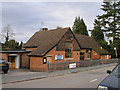
North Holmwood Village Hall
A much modified building next to the footpath which runs down to Image
Image: © Andy Potter
Taken: 7 Dec 2007
0.02 miles
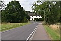
2
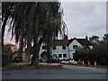
Spook Hollow House
Great place for Christmas lights, built 1850
Image: © Sam Booth
Taken: 26 Sep 2020
0.03 miles
3
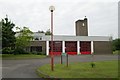
Dorking fire station
Dorking fire station, Spook Hill, North Holmwood, Dorking. This station replaced Image
Image: © Kevin Hale
Taken: 17 Jun 2007
0.04 miles
4
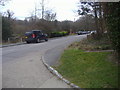
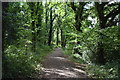
Spook Hill, North Holmwood
Looking south
Image: © David Howard
Taken: 14 Mar 2010
0.06 miles
5
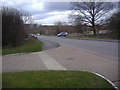
Spook Hill
The road through North Holmwood making a short cut on the A24
Image: © David Howard
Taken: 14 Mar 2010
0.07 miles
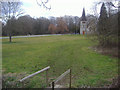
9
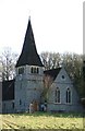
Detail of North Holmwood Church
Looking East from Flint Hill.
Image: © Martyn Davies
Taken: 11 Jan 2006
0.11 miles