IMAGES TAKEN NEAR TO
Punchbowl Lane, DORKING, RH5 4EA
Introduction
This page details the photographs taken nearby to Punchbowl Lane, RH5 4EA by members of the Geograph project.
The Geograph project started in 2005 with the aim of publishing, organising and preserving representative images for every square kilometre of Great Britain, Ireland and the Isle of Man.

There are currently over 7.5m images from over14,400 individuals and you can help contribute to the project by visiting https://www.geograph.org.uk
Image Map
Images are licensed for reuse under creativecommons.org/licenses/by-sa/2.0
Notes
- Clicking on the map will re-center to the selected point.
- The higher the marker number, the further away the image location is from the centre of the postcode.
Image Listing (36 Images Found)
Images are licensed for reuse under creativecommons.org/licenses/by-sa/2.0
Image
Details
Distance
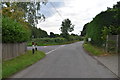
4
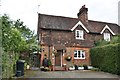
Junction of Tilehurst Lane and Punchbowl Lane
With Tilehurst on the right and Gamekeepers and Deerleap Cottages on the left.
Image: © Ian Capper
Taken: 10 Apr 2010
0.02 miles
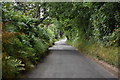
5
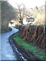
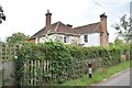
Tilehurst Farm
Looking West along Tilehurst Lane (see Image) towards Tilehurst Farm.
Image: © Martyn Davies
Taken: 11 Jan 2006
0.02 miles
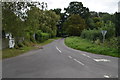
6
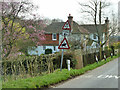
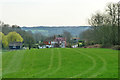
Road signs, Punchbowl Lane
Tilehurst Farm is beyond.
Image: © Robin Webster
Taken: 22 Mar 2011
0.02 miles