IMAGES TAKEN NEAR TO
Chart Lane South, DORKING, RH5 4DA
Introduction
This page details the photographs taken nearby to Chart Lane South, RH5 4DA by members of the Geograph project.
The Geograph project started in 2005 with the aim of publishing, organising and preserving representative images for every square kilometre of Great Britain, Ireland and the Isle of Man.

There are currently over 7.5m images from over14,400 individuals and you can help contribute to the project by visiting https://www.geograph.org.uk
Image Map
Images are licensed for reuse under creativecommons.org/licenses/by-sa/2.0
Notes
- Clicking on the map will re-center to the selected point.
- The higher the marker number, the further away the image location is from the centre of the postcode.
Image Listing (51 Images Found)
Images are licensed for reuse under creativecommons.org/licenses/by-sa/2.0
Image
Details
Distance
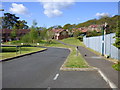
2
A24 Deepdene Avenue
The private road Glenwood off the A24 Deepdene Avenue.
Image: © P Harris
Taken: 3 Aug 2024
0.12 miles
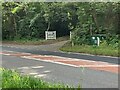
4
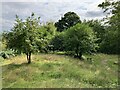
Deepdene Estate
Grounds within the Deepdene. Deepdene was an estate and country house occupying land to the southeast of Dorking.
Image: © P Harris
Taken: 3 Aug 2024
0.13 miles
5
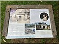
Hope Mausoleum, Deepdene Estate
Information board about the Hope Mausoleum. Deepdene was an estate and country house occupying land to the southeast of Dorking.
Image: © P Harris
Taken: 3 Aug 2024
0.13 miles
6
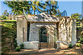
The Hope Mausoleum, The Deepdene
The Mausoleum erected by Thomas Hope in 1818 as a resting place for his son Charles who had died at the age of 7 a couple of years earlier. Thomas Hope's body was also placed here following his own death in 1831.
The Mausoleum suffered from vandalism and in 1957 it was bricked up and later buried to protect it. However, with support from the Mausolea and Monuments Trust, it has now undergone restoration and is again able to be viewed.
Image: © Ian Capper
Taken: 11 Sep 2016
0.14 miles
7

The Hope Mausoleum, The Deepdene
The Mausoleum erected by Thomas Hope in 1818 as a resting place for his son Charles who had died at the age of 7 a couple of years earlier. Thomas Hope's body was also placed here following his own death in 1831.
The Mausoleum suffered from vandalism and in 1957 it was bricked up and later buried to protect it. However, with support from the Mausolea and Monuments Trust, it has now undergone restoration and is again able to be viewed.
Image: © Ian Capper
Taken: 11 Sep 2016
0.14 miles
8
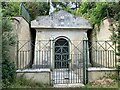
Hope Mausoleum, Deepdene Estate
The Hope Mausoleum in the Deepdene Estate. The banker Thomas Hope occupied Deepdene between 1806 and 1840, and constructed the mausoleum after the death of his 7 year old son. Thomas Hope was later also interred here. Deepdene was an estate and country house occupying land to the southeast of Dorking.
Image: © P Harris
Taken: 3 Aug 2024
0.14 miles
9
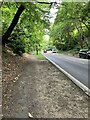
A24 Deepdene Avenue
Looking south along the A24 Deepdene Avenue.
Image: © P Harris
Taken: 3 Aug 2024
0.14 miles
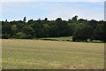
10

Deepdene Estate
Ornamental trees within the Deepdene. Deepdene was an estate and country house occupying land to the southeast of Dorking.
Image: © P Harris
Taken: 3 Aug 2024
0.15 miles