IMAGES TAKEN NEAR TO
Glenwood, DORKING, RH5 4BY
Introduction
This page details the photographs taken nearby to Glenwood, RH5 4BY by members of the Geograph project.
The Geograph project started in 2005 with the aim of publishing, organising and preserving representative images for every square kilometre of Great Britain, Ireland and the Isle of Man.

There are currently over 7.5m images from over14,400 individuals and you can help contribute to the project by visiting https://www.geograph.org.uk
Image Map
Images are licensed for reuse under creativecommons.org/licenses/by-sa/2.0
Notes
- Clicking on the map will re-center to the selected point.
- The higher the marker number, the further away the image location is from the centre of the postcode.
Image Listing (51 Images Found)
Images are licensed for reuse under creativecommons.org/licenses/by-sa/2.0
Image
Details
Distance
1
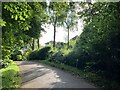
Glenwood, Dorking
The private road Glenwood.
Image: © P Harris
Taken: 3 Aug 2024
0.04 miles
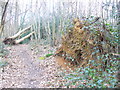
2
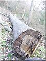
How the Mighty Have Fallen
Felled tree in Glory Wood, beside the Greensand Way.
Image: © Colin Smith
Taken: 7 Mar 2009
0.06 miles
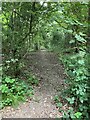
3
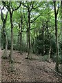
The Glory Wood, Dorking
Unmarked (on maps) path through the Glory Wood, Dorking.
Image: © P Harris
Taken: 28 Jun 2024
0.07 miles
4
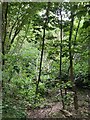
Devil's Den woods, Dorking
Faint path through thick vegetation in Devil's Den woods, Dorking.
Image: © P Harris
Taken: 28 Jun 2024
0.07 miles
5
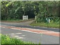
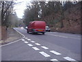
A24 Deepdene Avenue
The private road Glenwood off the A24 Deepdene Avenue.
Image: © P Harris
Taken: 3 Aug 2024
0.08 miles
6
Devil's Den woods, Dorking
Well defined path through Devils Den woods, Dorking
Image: © P Harris
Taken: 28 Jun 2024
0.09 miles
7
Greensand Way, Glory Wood
Good going underfoot on Tower Hill but some recently fallen trees impede progress through the wood. Birches and hollies are common along this stretch.
Image: © Colin Smith
Taken: 7 Mar 2009
0.11 miles
8
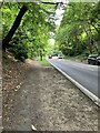
A24 Deepdene Avenue
Looking south along the A24 Deepdene Avenue.
Image: © P Harris
Taken: 3 Aug 2024
0.11 miles
9
Junction of Chart Lane and the A24, Dorking
Image: © David Howard
Taken: 30 Jan 2012
0.13 miles
10
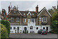
Denfield
A large Victorian house below Tower Hill, now subdivided into separate residences.
Image: © Ian Capper
Taken: 21 Oct 2016
0.14 miles