IMAGES TAKEN NEAR TO
Randall Close, DORKING, RH5 4BU
Introduction
This page details the photographs taken nearby to Randall Close, RH5 4BU by members of the Geograph project.
The Geograph project started in 2005 with the aim of publishing, organising and preserving representative images for every square kilometre of Great Britain, Ireland and the Isle of Man.

There are currently over 7.5m images from over14,400 individuals and you can help contribute to the project by visiting https://www.geograph.org.uk
Image Map
Images are licensed for reuse under creativecommons.org/licenses/by-sa/2.0
Notes
- Clicking on the map will re-center to the selected point.
- The higher the marker number, the further away the image location is from the centre of the postcode.
Image Listing (7 Images Found)
Images are licensed for reuse under creativecommons.org/licenses/by-sa/2.0
Image
Details
Distance
1
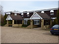
Beare Green: The 'British Raj'
The former Surrey Hills Hotel, now and Indian restaurant
Image: © Dr Neil Clifton
Taken: 13 Mar 2015
0.03 miles
2
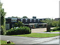
Surrey Hills Hotel
Near Beare Green south of the A24/A29 junction
Image: © Chris Shaw
Taken: Unknown
0.18 miles
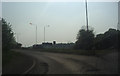
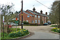
4
Original alignment of Bognor Road
This presumably dates from before the A24 roundabout and Capel bypass were built. Beare Green Cottages are built on the same alignment beyond these and Horsham Road.
Image: © Robin Webster
Taken: 17 Feb 2011
0.21 miles
5
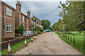
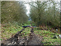
Beare Green Cottages
Row of late Victorian cottages overlooking the green at Beare Green.
Image: © Ian Capper
Taken: 4 Sep 2020
0.23 miles
7
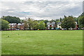
Beare Green Cottages
Row of late Victorian cottages overlooking the green at Beare Green.
Image: © Ian Capper
Taken: 4 Sep 2020
0.23 miles