IMAGES TAKEN NEAR TO
Deepdene Wood, DORKING, RH5 4BE
Introduction
This page details the photographs taken nearby to Deepdene Wood, RH5 4BE by members of the Geograph project.
The Geograph project started in 2005 with the aim of publishing, organising and preserving representative images for every square kilometre of Great Britain, Ireland and the Isle of Man.

There are currently over 7.5m images from over14,400 individuals and you can help contribute to the project by visiting https://www.geograph.org.uk
Image Map
Images are licensed for reuse under creativecommons.org/licenses/by-sa/2.0
Notes
- Clicking on the map will re-center to the selected point.
- The higher the marker number, the further away the image location is from the centre of the postcode.
Image Listing (29 Images Found)
Images are licensed for reuse under creativecommons.org/licenses/by-sa/2.0
Image
Details
Distance
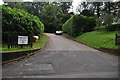
1
Modern house on Punchbowl Lane, Deepdene
It looks like it's from the early 70s or so.
Image: © David Howard
Taken: 27 Nov 2016
0.08 miles
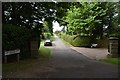
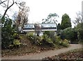
7
Hillspur
Reached via Park Copse, a private road off Punchbowl Lane, this is one of several large houses on the street. It is set facing south-east, with good views.
Image: © Robin Webster
Taken: 22 Mar 2011
0.13 miles
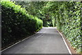
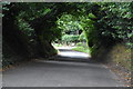
8
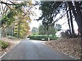
Punchbowl Lane, Deepdene
This is where suburban Dorking starts to become countryside.
Image: © David Howard
Taken: 27 Nov 2016
0.14 miles
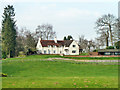
9
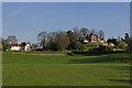
Houses in Park Copse
Viewed from Punchbowl Lane. Hillspur on the left and Burntwood House on the right.
Image: © Ian Capper
Taken: 10 Apr 2010
0.16 miles