IMAGES TAKEN NEAR TO
Guildford Road, DORKING, RH4 3NR
Introduction
This page details the photographs taken nearby to Guildford Road, RH4 3NR by members of the Geograph project.
The Geograph project started in 2005 with the aim of publishing, organising and preserving representative images for every square kilometre of Great Britain, Ireland and the Isle of Man.

There are currently over 7.5m images from over14,400 individuals and you can help contribute to the project by visiting https://www.geograph.org.uk
Image Map
Images are licensed for reuse under creativecommons.org/licenses/by-sa/2.0
Notes
- Clicking on the map will re-center to the selected point.
- The higher the marker number, the further away the image location is from the centre of the postcode.
Image Listing (115 Images Found)
Images are licensed for reuse under creativecommons.org/licenses/by-sa/2.0
Image
Details
Distance
1
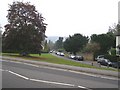
Shops overlooking the village green at Westcott
The road running along the south side of the green is the A25.
Image: © Stefan Czapski
Taken: 3 Aug 2011
0.01 miles
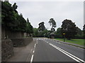
2
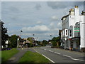
Westcott, Surrey
Looking along Guildford Road, as it runs through the village.
Image: © Peter Trimming
Taken: 16 Jul 2009
0.01 miles
3
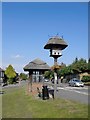
Thatched(!) dovecote and thatched(!) bus-shelter on the village green, Westcott
I have childhood memories of the London Transport country buses which used to serve the Dorking area - they always seemed very handsome, painted deep green with gold lettering. Try as I might, I couldn't dream one into the picture on this August afternoon.
The view is eastward, along the A25.
Image: © Stefan Czapski
Taken: 3 Aug 2011
0.01 miles
4
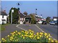
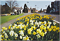
Westcott - Guildford Road
Daffodils blooming in the spring sunshine beside Westcott's landmark thatched bus stop and dovecot.
Image: © Colin Smith
Taken: 20 Mar 2015
0.01 miles
6
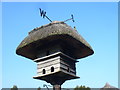
Westcott - Dovecot
Landmark thatched dovecote, topped by a weathervane, beside Westcott's thatched bus shelter.
Image: © Colin Smith
Taken: 20 Mar 2015
0.02 miles
7
Bus stop at Westcott
looking north-east
Image: © Andrew Longton
Taken: 28 Sep 2005
0.02 miles
8
Westcott
Almost a suburb of Dorking but Westcott has its own small green, seen above on the left. In the middle distance is a thatched doocot, marking the village's name. The bus stop is also thatched.
Image: © Colin Smith
Taken: Unknown
0.02 miles
9
Westcott Street
Westcott Street, with some of Ranmore Common visible in the hazy background.
Image: © Brian Green
Taken: 22 Oct 2007
0.02 miles
10
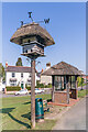
Dovecote and bus shelter
A thatched dovecote and bus shelter on Westcott Green. A plaque on the shelter states that "This Dovecote and Bus Shelter were given to the Village of Westcott by John Burnet Geake in memory of his son 2nd Lt. Boyd Burnet Geake who was killed 1st July 1916 at the Battle of the Somme" (see Image for close up). Unusually the letters on the weathervane on the dovecote has the letter T in place of the usual N, to read WEST. (In this photo they are wrongly aligned, but comparison with a 2009 photo (see Image) suggests that this is a recent change, perhaps from wind damage).
Image: © Ian Capper
Taken: 8 Mar 2022
0.02 miles