IMAGES TAKEN NEAR TO
Sandrock Road, DORKING, RH4 3LD
Introduction
This page details the photographs taken nearby to Sandrock Road, RH4 3LD by members of the Geograph project.
The Geograph project started in 2005 with the aim of publishing, organising and preserving representative images for every square kilometre of Great Britain, Ireland and the Isle of Man.

There are currently over 7.5m images from over14,400 individuals and you can help contribute to the project by visiting https://www.geograph.org.uk
Image Map
Images are licensed for reuse under creativecommons.org/licenses/by-sa/2.0
Notes
- Clicking on the map will re-center to the selected point.
- The higher the marker number, the further away the image location is from the centre of the postcode.
Image Listing (101 Images Found)
Images are licensed for reuse under creativecommons.org/licenses/by-sa/2.0
Image
Details
Distance
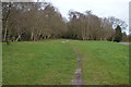
2
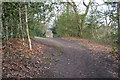
Public footpath at Westcott Heath near Dorking
A public footpath on Westcott Heath, near Dorking. The path forms part of the Greensand Way.
The road is also called Westcott Heath.
Image: © Malc McDonald
Taken: 28 Jul 2019
0.09 miles
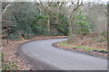
4
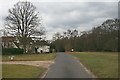
Westcott Heath
Several houses are found on the south side of the minor road, Westcott Common, which loops round Westcott Heath from the main road, the Guildford Road (A25). Surprisingly, the Heath is not registered common land, although it appears well looked after.
Image: © Hugh Craddock
Taken: 9 Mar 2010
0.10 miles
5
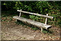
Westcott Memorial Bench
Commemorating three adults and six children, killed in an air raid on the night of 4th/5th January 1944. Bombs were dropped on nearby Watson Road.
Image: © Peter Trimming
Taken: 7 Aug 2020
0.11 miles
6
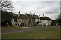
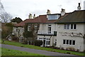
Menawethan, The Middle House and Pippacre
Three houses set on the south side of Westcott Common.
Image: © Hugh Craddock
Taken: 9 Mar 2010
0.11 miles
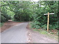
7

Pond by Westcott
This glimpse of a very secluded pond shows a house reflected in the water. The pond is here because the Pipp Brook has been dammed.
Image: © Colin Smith
Taken: 20 Oct 2007
0.11 miles
8
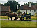
Westcott Heath
Horse drawn cart crossing Westcott Heath
Image: © Linda Singh
Taken: 28 Jun 2020
0.11 miles