IMAGES TAKEN NEAR TO
Logmore Lane, DORKING, RH4 3JL
Introduction
This page details the photographs taken nearby to Logmore Lane, RH4 3JL by members of the Geograph project.
The Geograph project started in 2005 with the aim of publishing, organising and preserving representative images for every square kilometre of Great Britain, Ireland and the Isle of Man.

There are currently over 7.5m images from over14,400 individuals and you can help contribute to the project by visiting https://www.geograph.org.uk
Image Map
Images are licensed for reuse under creativecommons.org/licenses/by-sa/2.0
Notes
- Clicking on the map will re-center to the selected point.
- The higher the marker number, the further away the image location is from the centre of the postcode.
Image Listing (4 Images Found)
Images are licensed for reuse under creativecommons.org/licenses/by-sa/2.0
Image
Details
Distance
1

Squire's Farm
They breed and train polo ponies here, and there is a large flock of very clean Swaledale sheep. The complex of bridleways around the farm is clearly signposted, so there is no excuse for trespass.
Image: © Dr Neil Clifton
Taken: 20 May 2015
0.01 miles
2
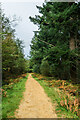
Squire's Great Wood
Path through Squire's Great Wood.
Image: © Ian Capper
Taken: 11 Oct 2021
0.16 miles
3
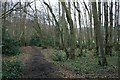
Bridleway in Bridlegate Copse
Public bridleway Dorking 573 through appropriately named Bridlegate Copse, between Logmore Green and Squire's Farm.
Image: © Hugh Craddock
Taken: 7 Feb 2010
0.20 miles
4
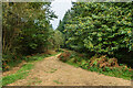
Squire's Great Wood
Path through Squire's Great Wood.
Image: © Ian Capper
Taken: 11 Oct 2021
0.22 miles