IMAGES TAKEN NEAR TO
Logmore Lane, DORKING, RH4 3JJ
Introduction
This page details the photographs taken nearby to Logmore Lane, RH4 3JJ by members of the Geograph project.
The Geograph project started in 2005 with the aim of publishing, organising and preserving representative images for every square kilometre of Great Britain, Ireland and the Isle of Man.

There are currently over 7.5m images from over14,400 individuals and you can help contribute to the project by visiting https://www.geograph.org.uk
Image Map (14 Images)


Leaflet Map data © OpenStreetMap
Images are licensed for reuse under creativecommons.org/licenses/by-sa/2.0
Notes
- Clicking on the map will re-center to the selected point.
- The higher the marker number, the further away the image location is from the centre of the postcode.
Image Listing (14 Images Found)
Images are licensed for reuse under creativecommons.org/licenses/by-sa/2.0
Image
Details
Distance
3
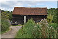
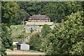
Barn, Collickmoor Farm
Grade II listed. https://historicengland.org.uk/listing/the-list/list-entry/1028761
Image: © N Chadwick
Taken: 28 Aug 2019
0.08 miles
4
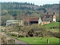
Collickmoor Farm
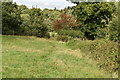
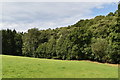
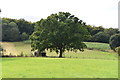
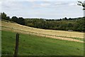
The farm and its fields are totally surrounded by Forestry Commission woodland.
Image: © Robin Webster
Taken: 4 Mar 2011
0.09 miles