IMAGES TAKEN NEAR TO
Junction Road, DORKING, RH4 3HB
Introduction
This page details the photographs taken nearby to Junction Road, RH4 3HB by members of the Geograph project.
The Geograph project started in 2005 with the aim of publishing, organising and preserving representative images for every square kilometre of Great Britain, Ireland and the Isle of Man.

There are currently over 7.5m images from over14,400 individuals and you can help contribute to the project by visiting https://www.geograph.org.uk
Image Map
Images are licensed for reuse under creativecommons.org/licenses/by-sa/2.0
Notes
- Clicking on the map will re-center to the selected point.
- The higher the marker number, the further away the image location is from the centre of the postcode.
Image Listing (539 Images Found)
Images are licensed for reuse under creativecommons.org/licenses/by-sa/2.0
Image
Details
Distance
1
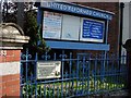
Dorking (Surrey): United Reformed Church
A building was erected on this site in West Street in 1719 to accommodate the growing congregations. This served until 1834, when the present church was built. Since then, many alterations and additions have been made.
In the early years, the church was known as the "Meeting House" and then as the "Independent Chapel". In the early 1900's the name "Congregational Chapel" came into use. This was gradually changed to the "Congregational Church"
Image: © Francois Thomas
Taken: 2 Apr 2007
0.01 miles
2
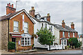
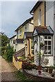
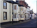
Highland Cottage, Hatton House and 1 - 2 Junction Road
Houses in Junction Road, first shown on the 1897 6 inch map. For many years Highland Cottage housed an eponymous restaurant, since replaced by an Indian Restaurant named The Dorking Brasserie.
Image: © Ian Capper
Taken: 11 Oct 2023
0.02 miles
3
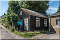
Tin hut
A corrugated iron hall situated off West street. A notice on the door suggests that it is used by the Scouts, presumably the 5th Dorking which are associated with the nearby URC Church in West Street.
Image: © Ian Capper
Taken: 11 Aug 2017
0.03 miles
4

Crossways Community Baptist Church
Church in Junction Road built in the 1860s/70s.
Image: © Ian Capper
Taken: 11 Oct 2023
0.03 miles
5
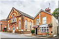
Crossways Community Baptist Church
Church in Junction Road built in the 1860s/70s. On the right is Highland Cottage which for many years housed an eponymous restaurant, since replaced by an Indian Restaurant named The Dorking Brasserie.
Image: © Ian Capper
Taken: 11 Oct 2023
0.03 miles
6
Rose's Cottages
Mid Victorian cottages off Junction Road. Shown in early maps as Rose Cottages, the name Rose's Cottages first appears on the 1914 1:2500 map
Image: © Ian Capper
Taken: 24 Sep 2016
0.04 miles
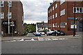
8
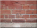
Cut Bench Mark Dorking Old Fire Station
Image: © dave-harris
Taken: 28 Feb 2012
0.04 miles
9
Cobbet's Real Ale
An excellent off licence and bar.
Image: © N Chadwick
Taken: 6 Feb 2016
0.04 miles
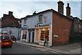
10
West Street , Dorking
Many antiques shops are in West Street. This view is of the south side of the street between its junctions with South Street and Junction Road.
Image: © Rib
Taken: 1 Feb 2007
0.04 miles