IMAGES TAKEN NEAR TO
Nower Road, DORKING, RH4 3BY
Introduction
This page details the photographs taken nearby to Nower Road, RH4 3BY by members of the Geograph project.
The Geograph project started in 2005 with the aim of publishing, organising and preserving representative images for every square kilometre of Great Britain, Ireland and the Isle of Man.

There are currently over 7.5m images from over14,400 individuals and you can help contribute to the project by visiting https://www.geograph.org.uk
Image Map
Images are licensed for reuse under creativecommons.org/licenses/by-sa/2.0
Notes
- Clicking on the map will re-center to the selected point.
- The higher the marker number, the further away the image location is from the centre of the postcode.
Image Listing (113 Images Found)
Images are licensed for reuse under creativecommons.org/licenses/by-sa/2.0
Image
Details
Distance
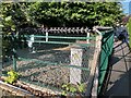
1

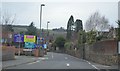
Wickes, Vincent Lane, Dorking
A large branch of the DIY and home improvements chain, which sells to both the trade and the public.
Image: © P L Chadwick
Taken: 28 Oct 2012
0.08 miles
2
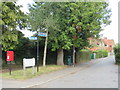
Nower Road, Dorking
The signpost indicates that this section of road is on the route of The Greensand Way, a long-distance footpath.
Image: © Malc McDonald
Taken: 28 Jul 2019
0.10 miles
3
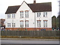
St.Joseph's Catholic Primary School, Dorking...looking East across Vincent Lane
Located at southern corner of Norfolk Road / Vincent Lane junction. Postcode RH4 3JA
Image: © Rib
Taken: 19 Jan 2006
0.10 miles
4
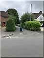
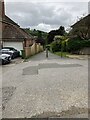
Nower Road
Start of a footpath linking Nower Road to West Bank in Dorking.
Image: © P Harris
Taken: 16 Jul 2024
0.10 miles
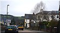
6
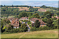
West Bank
Housing in West Bank seen from The Nower. In the background are the North Downs at Denbies.
Image: © Ian Capper
Taken: 11 Sep 2016
0.11 miles
7
West Bank
Start of a footpath linking the two sections of West Bank in Dorking.
Image: © P Harris
Taken: 16 Jul 2024
0.12 miles
9
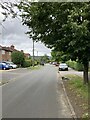
Nower Road
Looking north along Nower Road in Dorking.
Image: © P Harris
Taken: 16 Jul 2024
0.13 miles
10
West Bank, Dorking
Highly fortified electrical substation enclosure just off West Bank.
Image: © P Harris
Taken: 5 Aug 2024
0.13 miles