IMAGES TAKEN NEAR TO
Marley Rise, Ridgeway Road, DORKING, RH4 3BP
Introduction
This page details the photographs taken nearby to Marley Rise, Ridgeway Road, RH4 3BP by members of the Geograph project.
The Geograph project started in 2005 with the aim of publishing, organising and preserving representative images for every square kilometre of Great Britain, Ireland and the Isle of Man.

There are currently over 7.5m images from over14,400 individuals and you can help contribute to the project by visiting https://www.geograph.org.uk
Image Map
Images are licensed for reuse under creativecommons.org/licenses/by-sa/2.0
Notes
- Clicking on the map will re-center to the selected point.
- The higher the marker number, the further away the image location is from the centre of the postcode.
Image Listing (18 Images Found)
Images are licensed for reuse under creativecommons.org/licenses/by-sa/2.0
Image
Details
Distance
1
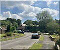
Ridgeway Drive, Dorking
View south along Ridgeway Drive, Dorking.
Image: © P Harris
Taken: 25 Jun 2024
0.05 miles
2
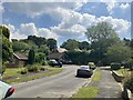
Ridgeway Drive, Dorking
Looking south along Ridgeway Drive, Dorking.
Image: © P Harris
Taken: 25 Jun 2024
0.06 miles
4
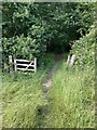
Dorking to North Holmwood footpath
Footpath junction and exit to fields.
Image: © P Harris
Taken: 14 Jul 2024
0.15 miles
5
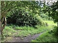
Footpath from North Holmwood to Dorking
Footpath enters woods on the way from North Holmwood to Dorking.
Image: © P Harris
Taken: 14 Jul 2024
0.15 miles
8
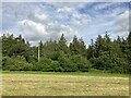
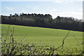
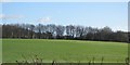
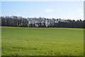
Countryside south of Dorking
View east to woodland and 11KV power line south of Dorking.
Image: © P Harris
Taken: 27 Jun 2024
0.18 miles
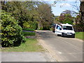
9
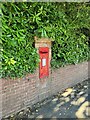
Tollgate Road, Dorking
Post box on Tollgate Road, Dorking.
Image: © P Harris
Taken: 21 Jun 2024
0.19 miles