IMAGES TAKEN NEAR TO
Firs Close, DORKING, RH4 3AW
Introduction
This page details the photographs taken nearby to Firs Close, RH4 3AW by members of the Geograph project.
The Geograph project started in 2005 with the aim of publishing, organising and preserving representative images for every square kilometre of Great Britain, Ireland and the Isle of Man.

There are currently over 7.5m images from over14,400 individuals and you can help contribute to the project by visiting https://www.geograph.org.uk
Image Map (Loading...)


Getting Data...Please wait
Leaflet Map data © OpenStreetMap
Images are licensed for reuse under creativecommons.org/licenses/by-sa/2.0
Notes
- Clicking on the map will re-center to the selected point.
- The higher the marker number, the further away the image location is from the centre of the postcode.
Image Listing (45 Images Found)
Images are licensed for reuse under creativecommons.org/licenses/by-sa/2.0
Image
Details
Distance
2
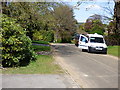
Ridgeway Drive, Dorking
Looking south along Ridgeway Drive, Dorking.
Image: © P Harris
Taken: 25 Jun 2024
0.12 miles
3
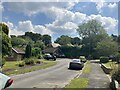
Ridgeway Drive, Dorking
View south along Ridgeway Drive, Dorking.
Image: © P Harris
Taken: 25 Jun 2024
0.13 miles
5
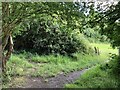
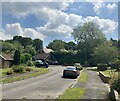
Dorking to North Holmwood footpath
Footpath junction and exit to fields.
Image: © P Harris
Taken: 14 Jul 2024
0.17 miles
6
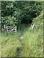
Footpath from North Holmwood to Dorking
Footpath enters woods on the way from North Holmwood to Dorking.
Image: © P Harris
Taken: 14 Jul 2024
0.17 miles
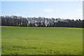
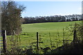
7
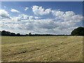
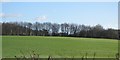
Fields south of Dorking
View to north west across farmland south of Dorking.
Image: © P Harris
Taken: 21 Jun 2024
0.17 miles
10
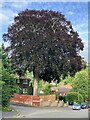
Copper beach tree, Knoll Road
Magnificent copper beach tree on Knoll Road, Dorking.
Image: © P Harris
Taken: 27 Jun 2024
0.18 miles