IMAGES TAKEN NEAR TO
Falkland Road, DORKING, RH4 3AD
Introduction
This page details the photographs taken nearby to Falkland Road, RH4 3AD by members of the Geograph project.
The Geograph project started in 2005 with the aim of publishing, organising and preserving representative images for every square kilometre of Great Britain, Ireland and the Isle of Man.

There are currently over 7.5m images from over14,400 individuals and you can help contribute to the project by visiting https://www.geograph.org.uk
Image Map
Images are licensed for reuse under creativecommons.org/licenses/by-sa/2.0
Notes
- Clicking on the map will re-center to the selected point.
- The higher the marker number, the further away the image location is from the centre of the postcode.
Image Listing (149 Images Found)
Images are licensed for reuse under creativecommons.org/licenses/by-sa/2.0
Image
Details
Distance
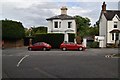
1
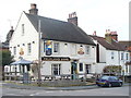
Falkland Arms
Young's pub at the top of Falkland Road in Dorking.
Image: © Colin Smith
Taken: 7 Mar 2009
0.03 miles
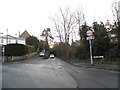
2
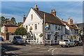
Falkland Arms
Mid 19th Century Pub at the junction of Falkland Road and Hampstead Road.
Image: © Ian Capper
Taken: 24 Sep 2016
0.05 miles
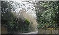
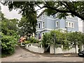
3
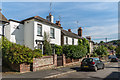
Hampstead Road
Victorian housing in Hampstead Road.
Image: © Ian Capper
Taken: 24 Sep 2016
0.05 miles
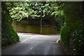
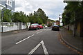
5
Vincent Lane at the junction of Coldharbour Lane
Image: © David Howard
Taken: 29 Dec 2014
0.05 miles
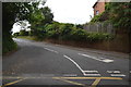
9
Falkland Grove
Junction of Falkland Grove with Hampstead Road, Dorking.
Image: © P Harris
Taken: 16 Jul 2024
0.07 miles