IMAGES TAKEN NEAR TO
Heathersland, DORKING, RH4 2LX
Introduction
This page details the photographs taken nearby to Heathersland, RH4 2LX by members of the Geograph project.
The Geograph project started in 2005 with the aim of publishing, organising and preserving representative images for every square kilometre of Great Britain, Ireland and the Isle of Man.

There are currently over 7.5m images from over14,400 individuals and you can help contribute to the project by visiting https://www.geograph.org.uk
Image Map
Images are licensed for reuse under creativecommons.org/licenses/by-sa/2.0
Notes
- Clicking on the map will re-center to the selected point.
- The higher the marker number, the further away the image location is from the centre of the postcode.
Image Listing (45 Images Found)
Images are licensed for reuse under creativecommons.org/licenses/by-sa/2.0
Image
Details
Distance
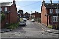
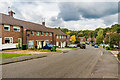
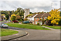
2
Glory Mead
Housing in Glory Mead on the Goodwyns Estate, a largely late 1950s housing estate built by Dorking Urban District Council on land compulsory purchased from local benefactor Howard Martineau, who until 1954 owned Goodwyns Place on Tower Hill, just to the north of the estate.
In the background are the two tower blocks on the estate, Linden Lea and Wenlock Edge.
Image: © Ian Capper
Taken: 21 Oct 2016
0.09 miles
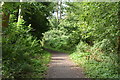
4
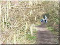
Footpath by Bents Brook
Catkins overhanging the path from North Holmwood to Stonebridge.
Image: © Colin Smith
Taken: 7 Mar 2009
0.10 miles
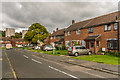
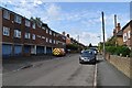
5
Goodwyns Road
Housing in Goodwyns Road on the Goodwyns Estate, a largely late 1950s housing estate built by Dorking Urban District Council on land compulsory purchased from local benefactor Howard Martineau, who until 1954 owned Goodwyns Place on Tower Hill, just to the north of the estate.
Image: © Ian Capper
Taken: 21 Oct 2016
0.10 miles
7
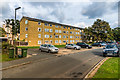
The Mead
Apartment block in Glory Meed on the Goodwyns Estate, a largely late 1950s housing estate built by Dorking Urban District Council on land compulsory purchased from local benefactor Howard Martineau, who until 1954 owned Goodwyns Place on Tower Hill, just to the north of the estate. In the left background, beyond another apartment block, Crouchfield, in Rushett Drive is one of the two tower blocks on the estate, Linden Lea.
Image: © Ian Capper
Taken: 21 Oct 2016
0.12 miles
8
Stubs Hill
Housing in Stubs Hill on the Goodwyns Estate, a largely late 1950s housing estate built by Dorking Urban District Council on land compulsory purchased from local benefactor Howard Martineau, who until 1954 owned Goodwyns Place on Tower Hill, just to the north of the estate.
In the background is one of the two tower blocks on the estate, Wenlock Edge (the other, Linden Lea is just visible behind the tree to its left).
Image: © Ian Capper
Taken: 21 Oct 2016
0.14 miles
9
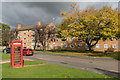
The Oaks
Apartment block in Oak Ridge on the Goodwyns Estate, a largely late 1950s housing estate built by Dorking Urban District Council on land compulsory purchased from local benefactor Howard Martineau, who until 1954 owned Goodwyns Place on Tower Hill, just to the north of the estate.
On the left is a K6 phone box.
Image: © Ian Capper
Taken: 21 Oct 2016
0.14 miles