IMAGES TAKEN NEAR TO
Victoria Terrace, DORKING, RH4 2LD
Introduction
This page details the photographs taken nearby to Victoria Terrace, RH4 2LD by members of the Geograph project.
The Geograph project started in 2005 with the aim of publishing, organising and preserving representative images for every square kilometre of Great Britain, Ireland and the Isle of Man.

There are currently over 7.5m images from over14,400 individuals and you can help contribute to the project by visiting https://www.geograph.org.uk
Image Map
Images are licensed for reuse under creativecommons.org/licenses/by-sa/2.0
Notes
- Clicking on the map will re-center to the selected point.
- The higher the marker number, the further away the image location is from the centre of the postcode.
Image Listing (571 Images Found)
Images are licensed for reuse under creativecommons.org/licenses/by-sa/2.0
Image
Details
Distance
1
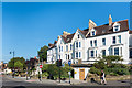
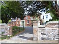
Victoria Terrace
Late 19th Century terrace on Butter Hill, above South Street. Below it (behind the "no entry" sign) is the town war memorial - see Image Old maps show that prior to the building of the war memorial, there was a line of buildings on the east side of South Street, presumably demolished to widen the road and erect the memorial and surrounding gardens.
Image: © Ian Capper
Taken: 1 Sep 2018
0.00 miles
2
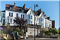
Victoria Terrace
Late 19th Century terrace on Butter Hill, above South Street. Below it is the town war memorial - see Image Old maps show that prior to the building of the war memorial, there was a line of buildings on the east side of South Street, presumably demolished to widen the road and erect the memorial and surrounding gardens.
Image: © Ian Capper
Taken: 1 Sep 2018
0.00 miles
3
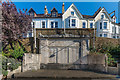
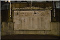
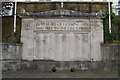
Dorking War Memorial
Town war memorial, unveiled in 1921. It was designed by Thomas Braddock, whose other works include Odeon cinemas; he was later MP for Mitcham between 1945 and 1950. The central panel commemorates the dead of the First World War, with the side panels added after 1945 listing the dead of the Second World War. Grade II listed - see www.historicengland.org.uk/listing/the-list/list-entry/1392420. Old maps show that prior to the building of the war memorial, there was a line of buildings on the east side of South Street, presumably demolished to widen the road and erect the memorial and surrounding gardens.
The buildings above are in Victoria Terrace. For wider view see Image
Image: © Ian Capper
Taken: 1 Sep 2018
0.01 miles
4

Red lips
A knitted cushion on a seat in South Street, advertising a Walking for Woman with Cancer event. I assume that the red lips are the work of Dorking's famed guerrilla knitters.
Image: © Ian Capper
Taken: 11 Aug 2017
0.01 miles
5
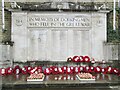
Dorking - War Memorial
On South Street, close to Pump Corner, with poppy wreaths and crosses.
Image: © Colin Smith
Taken: 25 Nov 2018
0.01 miles
6
Friends Cottage, Dorking
Quaker Meeting House in South Street.
Image: © David960
Taken: 27 Jul 2014
0.02 miles
7
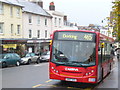
All Change!
End of the line for this bus on Dorking's South Street, just a few yards from the town's historic Pump Corner. The bus route comes from Kingston-upon-Thames via Leatherhead.
Image: © Colin Smith
Taken: 16 Nov 2008
0.02 miles
8
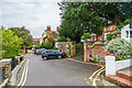
Butter Hill
Looking along Butter Hill with the Friends' Meeting House on the right (see Image) and Buttterhill House/Rose Hill House in the background (see Image).
Image: © Ian Capper
Taken: 11 Oct 2023
0.02 miles
9
Dorking War Memorial
Grade II listed. http://www.britishlistedbuildings.co.uk/en-504373-dorking-war-memorial-surrey
Image: © N Chadwick
Taken: 6 Feb 2016
0.02 miles
10
Dorking War Memorial
Grade II listed. https://historicengland.org.uk/listing/the-list/list-entry/1392420
Image: © N Chadwick
Taken: 28 Aug 2019
0.02 miles