IMAGES TAKEN NEAR TO
Horsham Road, DORKING, RH4 2JE
Introduction
This page details the photographs taken nearby to Horsham Road, RH4 2JE by members of the Geograph project.
The Geograph project started in 2005 with the aim of publishing, organising and preserving representative images for every square kilometre of Great Britain, Ireland and the Isle of Man.

There are currently over 7.5m images from over14,400 individuals and you can help contribute to the project by visiting https://www.geograph.org.uk
Image Map
Images are licensed for reuse under creativecommons.org/licenses/by-sa/2.0
Notes
- Clicking on the map will re-center to the selected point.
- The higher the marker number, the further away the image location is from the centre of the postcode.
Image Listing (156 Images Found)
Images are licensed for reuse under creativecommons.org/licenses/by-sa/2.0
Image
Details
Distance
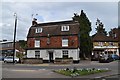
2
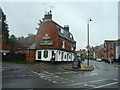
The Queens Head Public House, Dorking
Image: © Stacey Harris
Taken: 17 May 2009
0.03 miles
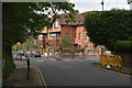
3
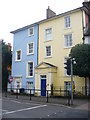
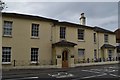
Georgian South Street, Dorking
Pastel colours brighten up this large Georgian building on the south-western edge of Dorking's town centre.
Image: © Colin Smith
Taken: 7 Mar 2009
0.04 miles
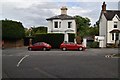
4
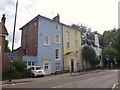
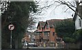
South Street, Dorking
Grade II listed houses: http://www.britishlistedbuildings.co.uk/en-404644-113-and-115-south-street-surrey
Image: © David960
Taken: 27 Jul 2014
0.04 miles