IMAGES TAKEN NEAR TO
St. Pauls Mews, DORKING, RH4 2HP
Introduction
This page details the photographs taken nearby to St. Pauls Mews, RH4 2HP by members of the Geograph project.
The Geograph project started in 2005 with the aim of publishing, organising and preserving representative images for every square kilometre of Great Britain, Ireland and the Isle of Man.

There are currently over 7.5m images from over14,400 individuals and you can help contribute to the project by visiting https://www.geograph.org.uk
Image Map
Images are licensed for reuse under creativecommons.org/licenses/by-sa/2.0
Notes
- Clicking on the map will re-center to the selected point.
- The higher the marker number, the further away the image location is from the centre of the postcode.
Image Listing (83 Images Found)
Images are licensed for reuse under creativecommons.org/licenses/by-sa/2.0
Image
Details
Distance
1
St Pauls Mews
Gated terrace of houses off St Pauls Road West, built in 2004-5.
Image: © Ian Capper
Taken: 11 Sep 2016
0.01 miles
2
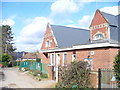
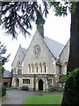
St Paul's School
CE Primary school on St Paul's Road in south Dorking. Modern extensions are to right, off camera.
Image: © Colin Smith
Taken: 7 Mar 2009
0.02 miles
4
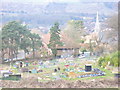
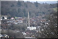
Allotments by Tower Hill
Rural-urban fringe activity on the slopes of Tower Hill on the southern edge of Dorking. St Martin's spire is in the middle distance (right). In the far distance are the lower slopes of Ranmore Common.
Image: © Colin Smith
Taken: 7 Mar 2009
0.08 miles
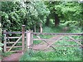
6
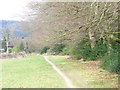
Greensand Way, South Dorking
Looking downhill towards St Paul's School. The path here is narrow, sandy and has drained well after a night of heavy rain.
Image: © Colin Smith
Taken: 7 Mar 2009
0.10 miles
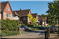
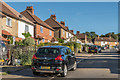
7

St Pauls Road East
Housing on a private road running down onto Chart Lane. In the background is Box Hill.
Image: © Ian Capper
Taken: 11 Sep 2016
0.12 miles
8
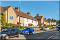
Beresford Road
Estate built for the then Dorking Urban District Council in 1927-8.
Image: © Ian Capper
Taken: 11 Sep 2016
0.13 miles
9
Beresford Road
Estate built for the then Dorking Urban District Council in 1927-8.
Image: © Ian Capper
Taken: 11 Sep 2016
0.13 miles