IMAGES TAKEN NEAR TO
White Horse Mews, DORKING, RH4 2FX
Introduction
This page details the photographs taken nearby to White Horse Mews, RH4 2FX by members of the Geograph project.
The Geograph project started in 2005 with the aim of publishing, organising and preserving representative images for every square kilometre of Great Britain, Ireland and the Isle of Man.

There are currently over 7.5m images from over14,400 individuals and you can help contribute to the project by visiting https://www.geograph.org.uk
Image Map
Images are licensed for reuse under creativecommons.org/licenses/by-sa/2.0
Notes
- Clicking on the map will re-center to the selected point.
- The higher the marker number, the further away the image location is from the centre of the postcode.
Image Listing (578 Images Found)
Images are licensed for reuse under creativecommons.org/licenses/by-sa/2.0
Image
Details
Distance
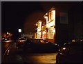
3

Dene Street, Dorking
Western side of street looking south from its junction with High Street.
Image: © Rib
Taken: 15 Jan 2007
0.02 miles
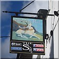
6
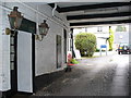
White Horse Hotel Yard
Covered lane in the 400 year old coaching inn on the south side of Dorking's High Street.
Image: © Colin Smith
Taken: 16 Nov 2008
0.02 miles
7
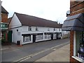
Downs Solicitors and Notaries
In Dene Street, Dorking.
Image: © David960
Taken: 27 Jul 2014
0.03 miles
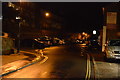
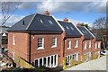
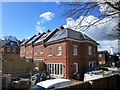
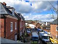
9
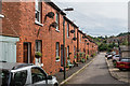
Dene Street Gardens
Early 20th Century terraced housing in a cul-de-sac off Dene Street.
Image: © Ian Capper
Taken: 24 Sep 2016
0.03 miles