IMAGES TAKEN NEAR TO
Brunswick Walk, DORKING, RH4 2FQ
Introduction
This page details the photographs taken nearby to Brunswick Walk, RH4 2FQ by members of the Geograph project.
The Geograph project started in 2005 with the aim of publishing, organising and preserving representative images for every square kilometre of Great Britain, Ireland and the Isle of Man.

There are currently over 7.5m images from over14,400 individuals and you can help contribute to the project by visiting https://www.geograph.org.uk
Image Map
Images are licensed for reuse under creativecommons.org/licenses/by-sa/2.0
Notes
- Clicking on the map will re-center to the selected point.
- The higher the marker number, the further away the image location is from the centre of the postcode.
Image Listing (428 Images Found)
Images are licensed for reuse under creativecommons.org/licenses/by-sa/2.0
Image
Details
Distance
1
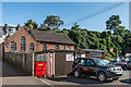
Dorking Baptist Chapel
Baptist Chapel built in the late 1890s/early 20th Century in what was once the grounds of Shrub Hill, a large house which was once the home of Baron Leslie, later Earl of Rothes, who was a Colonel of the Surrey Yeomanry.
Image: © Ian Capper
Taken: 26 Aug 2016
0.02 miles
2
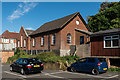
Dorking Baptist Chapel
Baptist Chapel built in the late 1890s/early 20th Century in what was once the grounds of Shrub Hill, a large house which was once the home of Baron Leslie, later Earl of Rothes, who was a Colonel of the Surrey Yeomanry.
Image: © Ian Capper
Taken: 26 Aug 2016
0.02 miles
3
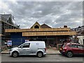
Moores Road, Dorking
Construction works for the new (rebuilt) Christian Science Church on Moores Road, Dorking.
Image: © P Harris
Taken: 28 Jun 2024
0.03 miles
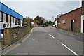
6
Cotmandene
A street of substantial Victorian houses overlooking a large green on a hill. This is just south of Dorking's High Street.
Image: © Colin Smith
Taken: 7 Mar 2009
0.04 miles
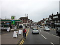
7
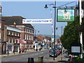
Dorking High Street
Wide main street in the old market town of Dorking. The flags are out in anticipation of the Royal Wedding. The large sign is outside the old coaching inn, The White Horse.
Image: © Colin Smith
Taken: 24 Apr 2011
0.04 miles
10
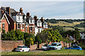
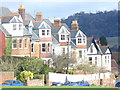
Villas, Cotmandene
Terrace of Edwardian villas in the northeast corner of Cotmandene. In the background is Box Hill.
Image: © Ian Capper
Taken: 24 Sep 2016
0.04 miles