IMAGES TAKEN NEAR TO
Beresford Road, DORKING, RH4 2DE
Introduction
This page details the photographs taken nearby to Beresford Road, RH4 2DE by members of the Geograph project.
The Geograph project started in 2005 with the aim of publishing, organising and preserving representative images for every square kilometre of Great Britain, Ireland and the Isle of Man.

There are currently over 7.5m images from over14,400 individuals and you can help contribute to the project by visiting https://www.geograph.org.uk
Image Map
Images are licensed for reuse under creativecommons.org/licenses/by-sa/2.0
Notes
- Clicking on the map will re-center to the selected point.
- The higher the marker number, the further away the image location is from the centre of the postcode.
Image Listing (318 Images Found)
Images are licensed for reuse under creativecommons.org/licenses/by-sa/2.0
Image
Details
Distance
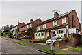
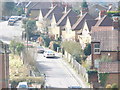
1
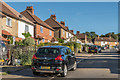
Beresford Road
Estate built for the then Dorking Urban District Council in 1927-8.
Image: © Ian Capper
Taken: 11 Sep 2016
0.01 miles
2
Beresford Road
Estate built for the then Dorking Urban District Council in 1927-8.
Image: © Ian Capper
Taken: 24 Sep 2016
0.02 miles
3
Beresford Road
Estate built for the then Dorking Urban District Council in 1927-8.
Image: © Ian Capper
Taken: 11 Sep 2016
0.03 miles
4
Beresford Road
Estate built for the then Dorking Urban District Council in 1927-8.
Image: © Ian Capper
Taken: 24 Sep 2016
0.03 miles
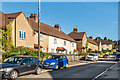
5
Cleardene
Cul-de-sac off Chart Lane. Although more recent in appearance, the development is on the 1934 revision of the 6" map, suggesting a 1920s or early 1930s building date.
Image: © Ian Capper
Taken: 24 Sep 2016
0.05 miles
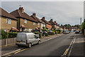
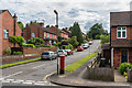
6
Marlborough Road
Estate built for the then Dorking Urban District Council in 1925-6 (although the nearest house is clearly more recent).
Image: © Ian Capper
Taken: 24 Sep 2016
0.06 miles
7
Cleardene
Cul-de-sac off Chart Lane (the road in the background). Although more recent in appearance, the development is on the 1934 revision of the 6" map, suggesting a 1920s or early 1930s building date.
Image: © Ian Capper
Taken: 11 Sep 2016
0.06 miles
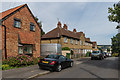
8
Cleardene
Cul-de-sac off Chart Lane. Although more recent in appearance, the development is on the 1934 revision of the 6" map, suggesting a 1920s or early 1930s building date.
Image: © Ian Capper
Taken: 11 Jun 2016
0.06 miles
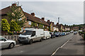
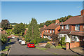
9
Marlborough Road
Residential road in south Dorking, climbing up Rose Hill from Cotmandene.
Image: © Colin Smith
Taken: 7 Mar 2009
0.06 miles
10

St Pauls Road East
Housing on a private road running down onto Chart Lane. In the background is Box Hill.
Image: © Ian Capper
Taken: 11 Sep 2016
0.07 miles