IMAGES TAKEN NEAR TO
Cotmandene, DORKING, RH4 2BT
Introduction
This page details the photographs taken nearby to Cotmandene, RH4 2BT by members of the Geograph project.
The Geograph project started in 2005 with the aim of publishing, organising and preserving representative images for every square kilometre of Great Britain, Ireland and the Isle of Man.

There are currently over 7.5m images from over14,400 individuals and you can help contribute to the project by visiting https://www.geograph.org.uk
Image Map
Images are licensed for reuse under creativecommons.org/licenses/by-sa/2.0
Notes
- Clicking on the map will re-center to the selected point.
- The higher the marker number, the further away the image location is from the centre of the postcode.
Image Listing (483 Images Found)
Images are licensed for reuse under creativecommons.org/licenses/by-sa/2.0
Image
Details
Distance
1
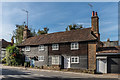
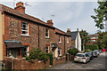
41 and 42 Dene Street
Pair of 18th Century cottages. Grade II listed - see https://www.historicengland.org.uk/listing/the-list/list-entry/1227820.
Image: © Ian Capper
Taken: 24 Sep 2016
0.01 miles
2
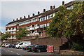
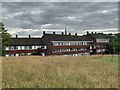
Flats, Dene Street
1970s block of flats above Dene Street, the other side of which overlooks Cotmandene (see Image).
Image: © Ian Capper
Taken: 24 Sep 2016
0.01 miles
3
35 - 38 Dene Street
17th Century terrace of cottages. Grade II listed - see https://www.historicengland.org.uk/listing/the-list/list-entry/1028893.
Image: © Ian Capper
Taken: 24 Sep 2016
0.02 miles
4
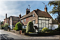
34 and 35 Dene Street
Two cottages in Dene Street. The one on the right forms the south wing of nos 35-38 Dene Street, built in the 17th Century. Grade II listed - see https://www.historicengland.org.uk/listing/the-list/list-entry/1028893.
Image: © Ian Capper
Taken: 24 Sep 2016
0.03 miles
5
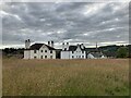
Cotmandene, Dorking
Several blocks of flats bordering Cotmandene.
Image: © P Harris
Taken: 28 Jun 2024
0.03 miles
6
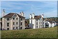
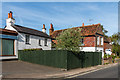
Housing, Cotmandene
Pair of mid 19th Century semi-detached villas overlooking Cotmandene.
Image: © Ian Capper
Taken: 24 Sep 2016
0.03 miles
7
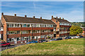
Flats, Cotmandene
1970s block of flats overlooking Cotmandene.
Image: © Ian Capper
Taken: 24 Sep 2016
0.03 miles
8
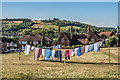
Cotmandene
Common land south of High Street, famous for cricket in the 18th Century. One of its features is the washing lines in the north west corner of the area, as seen here.
In the background are the North Downs at Denbies.
Image: © Ian Capper
Taken: 26 Aug 2016
0.03 miles
9
Cotmandene, Dorking
Large houses bordering Cotmandene with the spire of St Martin's Church in the background, and the Ranmore escarpment beyond.
Image: © P Harris
Taken: 28 Jun 2024
0.04 miles
10
Dene Street Gardens
Early 20th Century terraced housing in a cul-de-sac off Dene Street.
Image: © Ian Capper
Taken: 24 Sep 2016
0.04 miles