IMAGES TAKEN NEAR TO
Harrow Road East, DORKING, RH4 2AX
Introduction
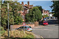
This page details the photographs taken nearby to Harrow Road East, RH4 2AX by members of the Geograph project.
The Geograph project started in 2005 with the aim of publishing, organising and preserving representative images for every square kilometre of Great Britain, Ireland and the Isle of Man.

There are currently over 7.5m images from over14,400 individuals and you can help contribute to the project by visiting https://www.geograph.org.uk
Image Map
Images are licensed for reuse under creativecommons.org/licenses/by-sa/2.0
Notes
- Clicking on the map will re-center to the selected point.
- The higher the marker number, the further away the image location is from the centre of the postcode.
Image Listing (61 Images Found)
Images are licensed for reuse under creativecommons.org/licenses/by-sa/2.0
Image
Details
Distance
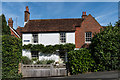
1
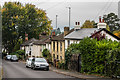
Harrow Road East
Late Victorian cottages in Harrow Road East.
Image: © Ian Capper
Taken: 21 Oct 2016
0.02 miles
2
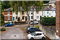
Orchard Way
Late Victorian terraced cottages on Orchard Way. Originally this was part of Orchard Road, part of which still exists to the west of here. However in the 1980s or so, Orchard Road was split into two, with the upper part, seen here, renamed and given its own access from Harrow Road East.
Image: © Ian Capper
Taken: 21 Oct 2016
0.05 miles
3
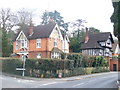
Horsham Road
Heading south from Dorking, fine cottages stand on the corner of Harrow Road East.
Image: © Colin Smith
Taken: 7 Mar 2009
0.06 miles
4
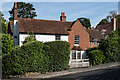
Harrow Cottage
Grade II listed cottage, part 18th Century and part with late 16th Century origins, on Harrow Road East - see https://www.historicengland.org.uk/listing/the-list/list-entry/1378069. Beyond it on the right is Kent Cottage, 17th Century and also grade II listed - see https://www.historicengland.org.uk/listing/the-list/list-entry/1287450.
Image: © Ian Capper
Taken: 24 Sep 2016
0.07 miles
5
Harrow Cottage
Grade II listed cottage, part 18th Century and part with late 16th Century origins, on Harrow Road East - see https://www.historicengland.org.uk/listing/the-list/list-entry/1378069.
Image: © Ian Capper
Taken: 24 Sep 2016
0.07 miles
6
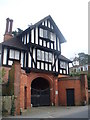
Gate House, Horsham Road
Wonderful mock Tudor extravaganza on the main road south from Dorking's High Street.
Image: © Colin Smith
Taken: 7 Mar 2009
0.07 miles
7
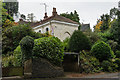
Priory Lodge
House on Harrow Road East, the wing of a larger building which the 1896 and 1914 1:2500 maps mark as the water works of the Dorking Water Company.
Image: © Ian Capper
Taken: 21 Oct 2016
0.08 miles
8
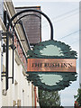
The Bush Inn sign
Sign for Image a pub on Flint Hill Close.
Image: © Oast House Archive
Taken: 6 Aug 2011
0.09 miles
9
Cliftonville
1880s road off Horsham Road, named after Joseph Clift, High Street Chemist and member of the Dorking District Local Board (the local council at the time), who was behind its development.
Image: © Ian Capper
Taken: 24 Sep 2016
0.09 miles
10
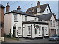
The Bush Inn, Dorking
Pub on Flint Hill Close.
Image: © Oast House Archive
Taken: 6 Aug 2011
0.10 miles