IMAGES TAKEN NEAR TO
St. Martins Walk, DORKING, RH4 1UW
Introduction
This page details the photographs taken nearby to St. Martins Walk, RH4 1UW by members of the Geograph project.
The Geograph project started in 2005 with the aim of publishing, organising and preserving representative images for every square kilometre of Great Britain, Ireland and the Isle of Man.

There are currently over 7.5m images from over14,400 individuals and you can help contribute to the project by visiting https://www.geograph.org.uk
Image Map
Images are licensed for reuse under creativecommons.org/licenses/by-sa/2.0
Notes
- Clicking on the map will re-center to the selected point.
- The higher the marker number, the further away the image location is from the centre of the postcode.
Image Listing (614 Images Found)
Images are licensed for reuse under creativecommons.org/licenses/by-sa/2.0
Image
Details
Distance
2
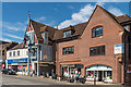
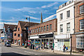
St Martin's Walk
The High Street frontage of St Martin's Walk, a small shopping mall completed in 1991, designed by London architects RHWL.
Image: © Ian Capper
Taken: 11 Aug 2017
0.01 miles
3
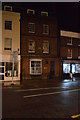
On Dorking High St
Grade II listed. http://www.britishlistedbuildings.co.uk/en-289935-155-161-high-street-surrey
Image: © N Chadwick
Taken: 6 Feb 2016
0.01 miles
4

Dorking
Low evening sun over central Dorking, as seen from Box Hill. Prominent on the right is the spire of St Martin's Church.
Image: © Ian Capper
Taken: 30 Jun 2012
0.01 miles
5
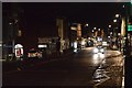
High Street, Dorking
Looking west from near the Dene Street junction.
Image: © David960
Taken: 27 Jul 2014
0.02 miles
6
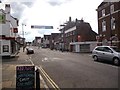
St Martin's Walk and 145-153 and 155-157 High Street
St Martin's Walk, the High Street frontage of which is on the left of the photo, was completed in 1991.
155-157 High Street, the 3 storey stuccoed building on the right of the photo, along with 159-161 High Street, the largely matching brick building, part of which can be seen to its right, were late 18th/early 19th Century houses and are grade II listed - see www.historicengland.org.uk/listing/the-list/list-entry/1028869.
Old photos would suggest there was once a third matching building in this group. This is because the building in the centre of the photo, 145-153 High Street, would appear to have once been a smaller building in two ways. The left hand section (with 6 windows at first floor level), currently housing The Original Factory Shop, was until closure in 2008, the Dorking branch of Woolworths. Francis Frith photos from c.1937 www.francisfrith.com/dorking/dorking-high-street-1937_87851 and c.1955 www.francisfrith.com/dorking/dorking-high-street-c1955_d45049 show it as a single storey building, whilst ones from c.1960 www.francisfrith.com/dorking/dorking-high-street-c1960_d45247 and c.1965 www.francisfrith.com/dorking/dorking-high-street-c1965_d45169 shows it with the first storey added. However in all these what is now the right hand section (with 4 windows at first floor level) appears to be a 3 storey building, similar to 155-161 High Street, suggesting that this was subsequently demolished and replaced with an extension of the Woolworths building. A join can be seen in the first floor brickwork between the 6th and 7th window, which is consistent with it being a later addition.
The top of the spire of St Martin's Church can be seen behind.
Image: © Ian Capper
Taken: 11 Aug 2017
0.02 miles
8
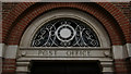
Clock face within decorative fanlight, Dorking Post Office
Image: © Jim Osley
Taken: 28 Jul 2012
0.02 miles
9

After the road race
... a cyclist takes advantage of a rare car-free Dorking High Street after the men's Olympic Road Race has passed through the town on Saturday 28 July 2012. The building in the background is the post office
Image: © Jim Osley
Taken: 28 Jul 2012
0.02 miles
