IMAGES TAKEN NEAR TO
Riverside, DORKING, RH4 1PR
Introduction
This page details the photographs taken nearby to Riverside, RH4 1PR by members of the Geograph project.
The Geograph project started in 2005 with the aim of publishing, organising and preserving representative images for every square kilometre of Great Britain, Ireland and the Isle of Man.

There are currently over 7.5m images from over14,400 individuals and you can help contribute to the project by visiting https://www.geograph.org.uk
Image Map
Images are licensed for reuse under creativecommons.org/licenses/by-sa/2.0
Notes
- Clicking on the map will re-center to the selected point.
- The higher the marker number, the further away the image location is from the centre of the postcode.
Image Listing (141 Images Found)
Images are licensed for reuse under creativecommons.org/licenses/by-sa/2.0
Image
Details
Distance
1
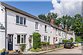
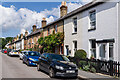
Riverside
Late 19th Century cottages in a cul-de-sac off Leslie Road.
Image: © Ian Capper
Taken: 3 Aug 2021
0.01 miles
2
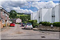
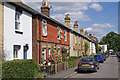
Riverside
Cul-de-sac off Leslie Road. The original houses in the road are two terraces of late 19th Century cottages (see Image), part of one of which is visible in the background. Riverside Court (on the left) and the flats in nos 19 - 36 (on the right) are much more recent, both dating from the c.1970s the former replacing a block of 3 terraced cottages in Leslie Road and the latter a late 19th Century house named Kenclare.
Image: © Ian Capper
Taken: 3 Aug 2021
0.02 miles
3
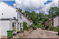
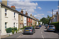
Riverside
Late 19th Century cottages in a cul-de-sac off Leslie Road, originally named Moleside.
Image: © Ian Capper
Taken: 3 Aug 2021
0.02 miles
4
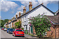
Leslie Road
Late 19th Century cottages in a cul-de-sac off Pixham Lane.
Image: © Ian Capper
Taken: 3 Aug 2021
0.02 miles
5
Leslie Road
Late 19th Century cottages in a cul-de-sac off Pixham Lane.
Image: © Ian Capper
Taken: 3 Aug 2021
0.03 miles
6

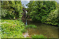
Railway viaduct over the River Mole at Pixham
In early June both river and viaduct are largely hidden by trees and other luxuriant vegetation. In the foreground are the gardens - somewhat suburban in style - of properties in Riverside, off Leslie Road, Pixham.
The railway line is the Redhill-Guildford- Reading line, built in early Victorian times by the South Eastern Railway. For a bit more history, see http://www.geograph.org.uk/photo/2209949
Image: © Stefan Czapski
Taken: 9 Jun 2012
0.05 miles
7
Leslie Road
Late Victorian housing in the Pixham area of Dorking.
Image: © Ian Capper
Taken: 5 Jul 2010
0.05 miles
8
Leslie Road
Late Victorian housing in the Pixham area of Dorking.
Image: © Ian Capper
Taken: 5 Jul 2010
0.05 miles
9

River Mole
Bridge pillars, for the railway bridge. This stretch of the river is popular with anglers.
Image: © Peter Trimming
Taken: 9 Mar 2017
0.05 miles
10
Pixham Viaduct
Viaduct carrying the Redhill to Guildford railway over the River Mole.
Image: © Ian Capper
Taken: 13 May 2017
0.06 miles