IMAGES TAKEN NEAR TO
Pixham Lane, DORKING, RH4 1PQ
Introduction
This page details the photographs taken nearby to Pixham Lane, RH4 1PQ by members of the Geograph project.
The Geograph project started in 2005 with the aim of publishing, organising and preserving representative images for every square kilometre of Great Britain, Ireland and the Isle of Man.

There are currently over 7.5m images from over14,400 individuals and you can help contribute to the project by visiting https://www.geograph.org.uk
Image Map
Images are licensed for reuse under creativecommons.org/licenses/by-sa/2.0
Notes
- Clicking on the map will re-center to the selected point.
- The higher the marker number, the further away the image location is from the centre of the postcode.
Image Listing (146 Images Found)
Images are licensed for reuse under creativecommons.org/licenses/by-sa/2.0
Image
Details
Distance
1
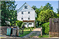
Pixham Mill
Mill building alongside the Pipp Brook, built in 1837. In its final years, up to ceasing operating in 1910, it was used by local firm Attlee's. It is now in residential use. Grade II listed - see www.historicengland.org.uk/listing/the-list/list-entry/1229433.
Image: © Ian Capper
Taken: 13 Jun 2021
0.00 miles
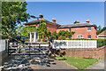
2
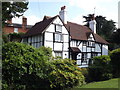
Old Cottage, Pixham
Timber-framed Surrey Building of Historic Interest in north-eastern Dorking.
www.visitdorking.com
Image: © Colin Smith
Taken: 9 Aug 2012
0.00 miles
3
Pixham Mill
Historic mill on the Pipp Brook at Pixham, Dorking.
www.visitdorking.com
Image: © Colin Smith
Taken: 9 Aug 2012
0.01 miles
4
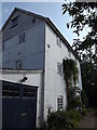
Pixham Mill Cottage
17th Century cottage adjacent to Pixham Mill (in background - see Image). Grade II listed - see www.historicengland.org.uk/listing/the-list/list-entry/1228834.
Image: © Ian Capper
Taken: 13 Jun 2021
0.01 miles
5
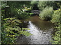
Pipp Brook, Pixham
Wide stream in Dorking, close to Pixham Mill, and to the Brook's mouth where it flows into the River Mole.
www.visitdorking.com
Image: © Colin Smith
Taken: 9 Aug 2012
0.02 miles
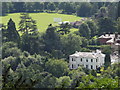
6
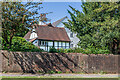
Pixham Mill House
Large house built in c.1839. Grade II listed - see www.historicengland.org.uk/listing/the-list/list-entry/1271210.
Image: © Ian Capper
Taken: 13 Jun 2021
0.02 miles
7

Footpath to Deepdene Station
An unusual route passing through gardens and passing a private house.
Image: © James Emmans
Taken: 9 Dec 2021
0.04 miles
8
Pixham from Box Hill
View south-westwards to this suburb of Dorking. Dorking Cricket Club is prominent with its wide expanse of grass.
Image: © Colin Smith
Taken: 9 Aug 2012
0.06 miles
9
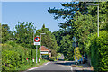
Pixham Lane
Looking north along Pixham Lane near Pixham Sports ground. The pinchpoint here was one of a number of measures introduced in the early 2000s in an attempt to control speed along the lane, following the removal of an experimental road closure in early 2003 which (predictably) caused traffic chaos over a large area. The sign here is a replacement in May 2021 of the previous one which had apparently been damaged - however, whereas the previous one was the correct one for "Priority over oncoming vehicles", the replacement uses the one appropriate to opposing traffic signifying "Give way to oncoming vehicles", but turned upside down, which is both incorrect and confusing from a distance. Surrey County Council have been informed of the issue, which hopefully will be corrected. See Image for a close up of the sign and Image for the corresponding (correct) sign for southbound traffic.
Postscript: Within a week of the incorrect sign being reported to Surrey County Council, it was replaced with the correct version (see Image).
Image: © Ian Capper
Taken: 13 Jun 2021
0.07 miles
10
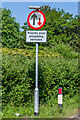
Incorrect road sign
Incorrect road sign in Pixham Lane. The pinchpoint here was one of a number of measures introduced in the early 2000s in an attempt to control speed along the lane, following the removal of an experimental road closure in early 2003 which (predictably) caused traffic chaos over a large area. The sign here is a replacement in May 2021 of the previous one which had apparently been damaged - however, whereas the previous one was the correct one for "Priority over oncoming vehicles" (a blue rectangle with a white upwards arrow and red downwards arrow), the replacement uses the one appropriate to opposing traffic signifying "Give way to oncoming vehicles", but turned upside down, which is both incorrect and confusing from a distance. Surrey County Council have been informed of the issue, which hopefully will be corrected. See Image for a wider view and Image for the corresponding (correct) sign for southbound traffic.
Postscript: Within a week of the incorrect sign being reported to Surrey County Council, it was replaced with the correct version (see Image).
Image: © Ian Capper
Taken: 13 Jun 2021
0.07 miles