IMAGES TAKEN NEAR TO
Swan Mill Gardens, DORKING, RH4 1PN
Introduction
This page details the photographs taken nearby to Swan Mill Gardens, RH4 1PN by members of the Geograph project.
The Geograph project started in 2005 with the aim of publishing, organising and preserving representative images for every square kilometre of Great Britain, Ireland and the Isle of Man.

There are currently over 7.5m images from over14,400 individuals and you can help contribute to the project by visiting https://www.geograph.org.uk
Image Map
Images are licensed for reuse under creativecommons.org/licenses/by-sa/2.0
Notes
- Clicking on the map will re-center to the selected point.
- The higher the marker number, the further away the image location is from the centre of the postcode.
Image Listing (140 Images Found)
Images are licensed for reuse under creativecommons.org/licenses/by-sa/2.0
Image
Details
Distance
1
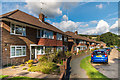
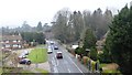
Swan Mill Gardens
Cul-de-sac off Pixham Lane built in 1958.
Image: © Ian Capper
Taken: 10 Oct 2016
0.02 miles
3
Swan Mill Gardens
Cul-de-sac off Pixham Lane built in 1958.
Image: © Ian Capper
Taken: 3 May 2010
0.04 miles

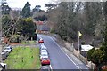
7
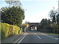
Railway bridge on Pixham Lane, Dorking
Image: © David Howard
Taken: 22 Sep 2014
0.05 miles
8
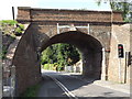
Pixham Lane Railway Bridge
Red brick bridge carrying the Dorking-Reigate line over narrow Pixham Lane. One way traffic through the arch is controlled by traffic lights.
www.visitdorking.com
Image: © Colin Smith
Taken: 9 Aug 2012
0.05 miles
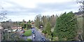
9
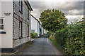
Pixholme Grove
A row of late 19th Century cottages off Pixham Lane.
Image: © Ian Capper
Taken: 10 Oct 2016
0.06 miles
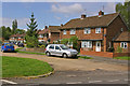
10

Swan Mill Gardens
Suburban street on the edge of Dorking
Image: © N Chadwick
Taken: 23 Jan 2011
0.06 miles