IMAGES TAKEN NEAR TO
Old Reigate Road, DORKING, RH4 1NS
Introduction
This page details the photographs taken nearby to Old Reigate Road, RH4 1NS by members of the Geograph project.
The Geograph project started in 2005 with the aim of publishing, organising and preserving representative images for every square kilometre of Great Britain, Ireland and the Isle of Man.

There are currently over 7.5m images from over14,400 individuals and you can help contribute to the project by visiting https://www.geograph.org.uk
Image Map
Images are licensed for reuse under creativecommons.org/licenses/by-sa/2.0
Notes
- Clicking on the map will re-center to the selected point.
- The higher the marker number, the further away the image location is from the centre of the postcode.
Image Listing (70 Images Found)
Images are licensed for reuse under creativecommons.org/licenses/by-sa/2.0
Image
Details
Distance
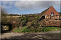
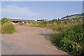
1
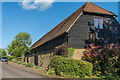
Boxhill Farm Barns
Barn conversions on Boxhill Farm.
Image: © Ian Capper
Taken: 14 May 2017
0.01 miles
2

Boxhill Farm
Boxhill Farm seen from Box Hill. The white area beyond is the roof of Dorking Garden Centre and in the background is Betchworth Park golf course.
Image: © Ian Capper
Taken: 30 Jun 2012
0.01 miles
3
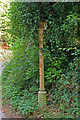
Former signpost, junction of Old Reigate Road and Boxhill Road
Remains of signpost at junction in Image Only the R of Reigate remains on the near finger.
Image: © Ian Capper
Taken: 24 Jul 2010
0.03 miles
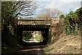
4
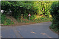
Junction of Old Reigate Road and Boxhill Road
Once part of the main road from Reigate to Dorking, with traffic having to make a sharp left turn in order to cross the River Mole at the former Boxhill Bridge (see Image However, it was bypassed when Deepdene Bridge was opened in 1927, and now serves only Boxhill Farm and Boxhurst. The low bridge sign is where Boxhill Road goes under the Redhill-Guildford railway. The steps on the left lead to a footpath across fields to Pixham (see Image for photo of the footpath leading towards this point).
For close up of the former signpost on the far right of the photo, see Image
Image: © Ian Capper
Taken: 24 Jul 2010
0.03 miles
5
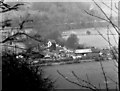
Lower Boxhill Farm, near Dorking, Surrey
Taken with a long lens from the Box Hill viewpoint
Image: © Dr Neil Clifton
Taken: 29 Dec 1977
0.03 miles
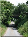
6
Boxhill Road
Looking towards the railway bridge, which carries the line from Redhill to Guildford. Beyond, lies the southern face of Box Hill.
Image: © Peter Trimming
Taken: 9 Mar 2017
0.04 miles
7
Boxhill Road
Looking towards the railway bridge, which carries the line from Redhill to Guildford.
Image: © Peter Trimming
Taken: 9 Mar 2017
0.04 miles
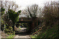
8
Boxhill Road railway bridge
Both sides of the bridge are lined with railings, giving the impression of an ornamental bridge over Boxhill Road. The road continues north up the hill to Boxhurst, and then as a rough and eroded track up the hill to emerge in the car park of the Smith & Western restaurant.
Image: © Hugh Craddock
Taken: 22 Jun 2008
0.04 miles
9
Boxhill Road
Looking towards the railway bridge, which carries the line from Redhill to Guildford.
Image: © Peter Trimming
Taken: 9 Mar 2017
0.04 miles
10
Entrance to Boxhill Farm
A working farm off Old Reigate Road. In the background is Box Hill itself.
Image: © Ian Capper
Taken: 24 Jul 2010
0.07 miles