IMAGES TAKEN NEAR TO
Reigate Road, DORKING, RH4 1NN
Introduction
This page details the photographs taken nearby to Reigate Road, RH4 1NN by members of the Geograph project.
The Geograph project started in 2005 with the aim of publishing, organising and preserving representative images for every square kilometre of Great Britain, Ireland and the Isle of Man.

There are currently over 7.5m images from over14,400 individuals and you can help contribute to the project by visiting https://www.geograph.org.uk
Image Map
Images are licensed for reuse under creativecommons.org/licenses/by-sa/2.0
Notes
- Clicking on the map will re-center to the selected point.
- The higher the marker number, the further away the image location is from the centre of the postcode.
Image Listing (117 Images Found)
Images are licensed for reuse under creativecommons.org/licenses/by-sa/2.0
Image
Details
Distance
1
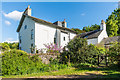
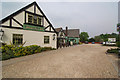
Castle Mill House
Early 19th Century house near Castle Mill. Grade II listed - see www.historicengland.org.uk/listing/the-list/list-entry/1229452.
Image: © Ian Capper
Taken: 14 May 2017
0.01 miles
2
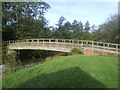
Footbridge over the River Mole
Wooden bridge crossing the mole from Castle Mill (see also Image) to Box Hill Farm.
Image: © Martyn Davies
Taken: 12 Oct 2006
0.01 miles
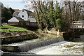
3
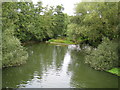
River Mole in Pixham
Viewed looking downstream from the footbridge in Image, the river has just come down off the weir and has formed a large, wide and probably quite deep weirpool here. As the river has slowed down all the particles carried by it over the weir have dropped to the bed and gradually accumulated to form the low grassy island visible in the middle of the river in the distance.
Image: © Nigel Cox
Taken: 20 Sep 2006
0.01 miles
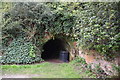
6
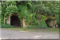
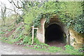
Caves
A pair of caves cut into the greensand south of Old Castle Mill.
Image: © Ian Capper
Taken: 14 May 2017
0.03 miles
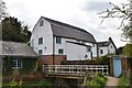
7
Castle Mill, Pixham
Located beside the River Mole, to the east of Dorking.
Image: © Peter Trimming
Taken: 9 Mar 2017
0.03 miles
8
Old Castle Mill
Grade II listed. https://historicengland.org.uk/listing/the-list/list-entry/1279088
Image: © N Chadwick
Taken: 12 Apr 2019
0.03 miles
9
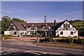
The Watermill
A 1930s pub/restaurant. Compare Image - this photo is after a rebrand. For close up of sign see Image In the background is Box Hill.
Image: © Ian Capper
Taken: 29 Aug 2011
0.03 miles
10
Watermill Inn, Dorking
This substantial pub and restaurant stands on the A25 Reigate Road to the east of the town.
Image: © Stephen McKay
Taken: 29 Apr 2011
0.03 miles