IMAGES TAKEN NEAR TO
Calvert Road, DORKING, RH4 1LS
Introduction
This page details the photographs taken nearby to Calvert Road, RH4 1LS by members of the Geograph project.
The Geograph project started in 2005 with the aim of publishing, organising and preserving representative images for every square kilometre of Great Britain, Ireland and the Isle of Man.

There are currently over 7.5m images from over14,400 individuals and you can help contribute to the project by visiting https://www.geograph.org.uk
Image Map (Loading...)


Getting Data...Please wait
Leaflet Map data © OpenStreetMap
Images are licensed for reuse under creativecommons.org/licenses/by-sa/2.0
Notes
- Clicking on the map will re-center to the selected point.
- The higher the marker number, the further away the image location is from the centre of the postcode.
Image Listing (118 Images Found)
Images are licensed for reuse under creativecommons.org/licenses/by-sa/2.0
Image
Details
Distance
1
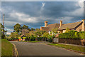
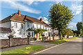
Calvert Road
Part of the Denbies Estate developed with upmarket housing in the late 1920s/early 1930s.
The name of the road presumably commemorates the surname by marriage of Beatrice Cubitt, daughter of George Cubitt, 1st Baron Ashcombe, whose family seat was Denbies. Beatrice married landowner and farmer William Calvert in 1891.
Image: © Ian Capper
Taken: 10 Oct 2016
0.01 miles
2
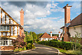
Calvert Gardens
Small upmarket development off Calvert Road, completed in 2014 on the site of the former Stanway School (New Lodge School from 2002 following merger with Nower Lodge School) which closed in 2007.
Image: © Ian Capper
Taken: 10 Oct 2016
0.03 miles
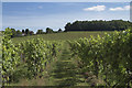
4
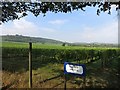
Calvert Road, Dorking
Along the southern edge of Denbies Vineyard.
Image: © Des Blenkinsopp
Taken: 18 Sep 2014
0.07 miles
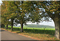
5
Chichester Road
Part of the Denbies Estate developed with upmarket housing in the late 1920s/early 1930s.
The name of the road commemorates the surname by marriage of Mary Cubitt, daughter of George Cubitt, 1st Baron Ashcombe, whose family seat was Denbies.
Image: © Ian Capper
Taken: 10 Oct 2016
0.10 miles
6
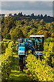
Grape harvesting at Denbies Vineyard
A Braud grape harvester at work at Denbies Vineyard. On the skyline is Norbury Park House.
Image: © Ian Capper
Taken: 10 Oct 2016
0.10 miles
7
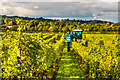
Grape harvesting at Denbies Vineyard
A Braud grape harvester at work at Denbies Vineyard, with the winery in the left background. On the skyline is Norbury Park House.
Image: © Ian Capper
Taken: 10 Oct 2016
0.10 miles
9
Denbies Wine Estate
The largest vineyard in England. http://en.wikipedia.org/wiki/Denbies_Wine_Estate
Image: © Des Blenkinsopp
Taken: 18 Sep 2014
0.10 miles
10
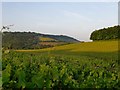
View across Denbies vineyard to the Mole Gap and Boxhill
View from the right of way which runs north-south through the vineyard. The vineyard is vast, and said to be the largest in Britain.
Image: © Stefan Czapski
Taken: 10 Jul 2013
0.10 miles