IMAGES TAKEN NEAR TO
Rothes Road, DORKING, RH4 1LB
Introduction
This page details the photographs taken nearby to Rothes Road, RH4 1LB by members of the Geograph project.
The Geograph project started in 2005 with the aim of publishing, organising and preserving representative images for every square kilometre of Great Britain, Ireland and the Isle of Man.

There are currently over 7.5m images from over14,400 individuals and you can help contribute to the project by visiting https://www.geograph.org.uk
Image Map
Images are licensed for reuse under creativecommons.org/licenses/by-sa/2.0
Notes
- Clicking on the map will re-center to the selected point.
- The higher the marker number, the further away the image location is from the centre of the postcode.
Image Listing (471 Images Found)
Images are licensed for reuse under creativecommons.org/licenses/by-sa/2.0
Image
Details
Distance
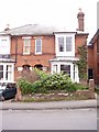
1
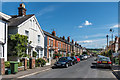
Rothes Road
Mainly late Victorian housing in a street running parallel with and north of High Street, with Box Hill in the background.
Image: © Ian Capper
Taken: 11 Aug 2017
0.01 miles
2
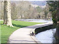
Pipp Brook
Canalized stream in central Dorking, flowing past the Mill Pond here. In the distance is Box Hill.
Image: © Colin Smith
Taken: 7 Mar 2009
0.02 miles
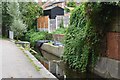
3
Footpath along Pipp Brook, Dorking
A footpath alongside Pipp Brook in Dorking, Surrey.
Image: © Malc McDonald
Taken: 28 Jul 2019
0.02 miles
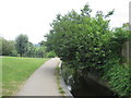
5

The Pipp Brook, Dorking
The walkway through Meadowbank Recreation Ground along the Pipp Brook, a tributary of the River Mole
Image: © Alan Hunt
Taken: 20 Apr 2015
0.03 miles
6
Birthplace of Actor Sir Laurence Olivier, Wathen Road, Dorking
looking North-East from Western side of road
Image: © Rib
Taken: 23 Jan 2006
0.03 miles
7
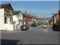
Rothes Road, Dorking
Looking east along Rothes Road from the junction with Ansell Road.
Image: © Alan Hunt
Taken: 20 Apr 2015
0.03 miles
8
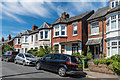
Rothes Road
Late Victorian housing in a street running parallel with and north of High Street.
Image: © Ian Capper
Taken: 11 Aug 2017
0.03 miles
9
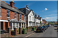
Rothes Road
Mainly late Victorian housing in a street running parallel with and north of High Street, with Box Hill in the distance.
Image: © Ian Capper
Taken: 11 Aug 2017
0.03 miles
10
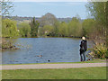
Meadowbank Lake
The lake in Meadowbank Recreation Area with Box Hill in the distance.
Image: © Alan Hunt
Taken: 20 Apr 2015
0.03 miles