IMAGES TAKEN NEAR TO
Masons Paddock, DORKING, RH4 1HY
Introduction
This page details the photographs taken nearby to Masons Paddock, RH4 1HY by members of the Geograph project.
The Geograph project started in 2005 with the aim of publishing, organising and preserving representative images for every square kilometre of Great Britain, Ireland and the Isle of Man.

There are currently over 7.5m images from over14,400 individuals and you can help contribute to the project by visiting https://www.geograph.org.uk
Image Map
Images are licensed for reuse under creativecommons.org/licenses/by-sa/2.0
Notes
- Clicking on the map will re-center to the selected point.
- The higher the marker number, the further away the image location is from the centre of the postcode.
Image Listing (115 Images Found)
Images are licensed for reuse under creativecommons.org/licenses/by-sa/2.0
Image
Details
Distance
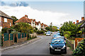
1
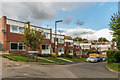
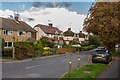
Masons Paddock
Housing off Chalkpit Terrace, built in 1966-7 in the former chalkpit to which that road's name refers.
Image: © Ian Capper
Taken: 10 Oct 2016
0.02 miles
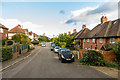
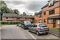
2
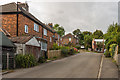
Chalkpit Terrace
1920s housing in a cul-de-sac off the main part of Chalkpit Terrace. The name refers to the nearby chalk pits and lime works, which were operational until the 1930s.
Image: © Ian Capper
Taken: 10 Oct 2016
0.03 miles
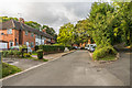
3
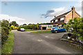
Hill Rise
Cul-de-sac off Limeway Terrace, occupying the site of Chalkpit House, which presumably was the house for the manager of the nearby chalk pits and lime works, which were operational until the 1930s.
Image: © Ian Capper
Taken: 10 Oct 2016
0.04 miles
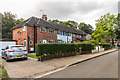
4
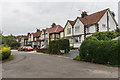
Chalkpit Terrace
1930s housing near the site of the former Dorking Lime Works.
Image: © Ian Capper
Taken: 10 Oct 2015
0.04 miles
5
Chalkpit Terrace
1920s housing in Chalkpit Terrace. The name refers to the nearby chalk pits and lime works, which were operational until the 1930s.
Image: © Ian Capper
Taken: 10 Oct 2016
0.05 miles
6
Chalkpit Terrace
1920s housing in Chalkpit Terrace. The name refers to the nearby chalk pits and lime works, which were operational until the 1930s.
Image: © Ian Capper
Taken: 10 Oct 2016
0.05 miles
7
Limeway Terrace
1920s housing in Limeway Terrace. The name refers to the nearby chalk pits and lime works, which were operational until the 1930s
Image: © Ian Capper
Taken: 10 Oct 2016
0.06 miles
8
Limeway Terrace
1920s housing in Limeway Terrace. The name refers to the nearby chalk pits and lime works, which were operational until the 1930s
Image: © Ian Capper
Taken: 10 Oct 2016
0.06 miles
9
Ashcombe Road
The earliest section of Ashcombe Road, first developed in the early 1900s.
Image: © Ian Capper
Taken: 10 Oct 2016
0.08 miles
10
Ranmore Park
1988 development on part of the site of the former Dorking Limeworks.
Image: © Ian Capper
Taken: 10 Oct 2016
0.08 miles