IMAGES TAKEN NEAR TO
Lyons Court, DORKING, RH4 1GN
Introduction
This page details the photographs taken nearby to Lyons Court, RH4 1GN by members of the Geograph project.
The Geograph project started in 2005 with the aim of publishing, organising and preserving representative images for every square kilometre of Great Britain, Ireland and the Isle of Man.

There are currently over 7.5m images from over14,400 individuals and you can help contribute to the project by visiting https://www.geograph.org.uk
Image Map
Images are licensed for reuse under creativecommons.org/licenses/by-sa/2.0
Notes
- Clicking on the map will re-center to the selected point.
- The higher the marker number, the further away the image location is from the centre of the postcode.
Image Listing (625 Images Found)
Images are licensed for reuse under creativecommons.org/licenses/by-sa/2.0
Image
Details
Distance
1
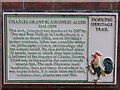
Charles Allen Plaque
One of many similar plaques detailing some of Dorking's history. This one is on the south side of the High Street. The signs all show the "five toed un", the famous Dorking cockerel.
Image]
Image: © Colin Smith
Taken: 24 Apr 2011
0.02 miles
2
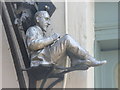
Charles Allen Figure
Whimsical figure of local Darwinian and writer of fact & fiction. It is located on Dorking High Street, south side.
Image]
Image: © Colin Smith
Taken: 24 Apr 2011
0.02 miles
3
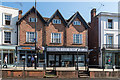
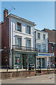
48 - 56 High Street
3 gabled building on High Street. Timber framed, refaced in the early 19th century. Grade II listed - see www.historicengland.org.uk/listing/the-list/list-entry/1378088. The bollards in front are separately grade II listed - see www.historicengland.org.uk/listing/the-list/list-entry/1378090.
Image: © Ian Capper
Taken: 1 Sep 2018
0.02 miles
4
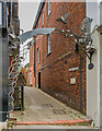
Allen Court
Alleyway off High Street to Allen Court with a decorative ironwork arch produced by Leatherhead firm Fire and Iron Gallery.
Image: © Ian Capper
Taken: 11 Oct 2023
0.02 miles
5
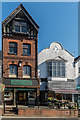
40 - 46 High Street
Pair of early 19th Century buildings on High Street. Grade II listed - see www.historicengland.org.uk/listing/the-list/list-entry/1287431. The bollards in front are separately grade II listed - see www.historicengland.org.uk/listing/the-list/list-entry/1378090.
Image: © Ian Capper
Taken: 1 Sep 2018
0.02 miles
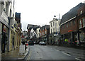
7
66 - 72 High Street
Contrasting buildings on High Street, nos 70 - 72 on the left and 66 - 68 on the right.
The bollards in front are grade II listed - see www.historicengland.org.uk/listing/the-list/list-entry/1378090.
Image: © Ian Capper
Taken: 1 Sep 2018
0.03 miles
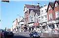
10
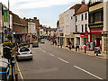
Dorking High Street
The west end of Dorking High Street on the A25 through the town.
Image: © Peter Kazmierczak
Taken: 26 Oct 2011
0.03 miles