IMAGES TAKEN NEAR TO
Pixham End, DORKING, RH4 1GB
Introduction
This page details the photographs taken nearby to Pixham End, RH4 1GB by members of the Geograph project.
The Geograph project started in 2005 with the aim of publishing, organising and preserving representative images for every square kilometre of Great Britain, Ireland and the Isle of Man.

There are currently over 7.5m images from over14,400 individuals and you can help contribute to the project by visiting https://www.geograph.org.uk
Image Map (Loading...)


Getting Data...Please wait
Leaflet Map data © OpenStreetMap
Images are licensed for reuse under creativecommons.org/licenses/by-sa/2.0
Notes
- Clicking on the map will re-center to the selected point.
- The higher the marker number, the further away the image location is from the centre of the postcode.
Image Listing (143 Images Found)
Images are licensed for reuse under creativecommons.org/licenses/by-sa/2.0
Image
Details
Distance
1
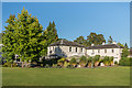
Pixham End
Sports and Social Club in the grounds of Aviva's (formerly Friends Provident) offices in Pixham Lane. The main part of the building is a Victorian house originally called Hazelbourne, renamed Pixham End in the 1920s or 1930s, the name since applied to the whole site.
Image: © Ian Capper
Taken: 11 Sep 2016
0.02 miles
2
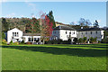
Friends Life social club, Dorking
The social club in the grounds of Friends Life with Box Hill providing the backdrop.
Image: © Alan Hunt
Taken: 21 Nov 2015
0.03 miles
3
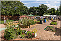
Patchworking Garden Project
Social gardening project in a former walled garden off Pixham Lane. For a period in the 1990s the site had seen temporary use as a car park by Friends Provident, while its offices on the other side of the road were being refurbished. The site later fell derelict until taken over by Patchworking who restored it to provide a place for people experiencing difficulties as a result of isolation, bereavement or recovery from either psychological or physical ill-health to take part in gardening activities.
Seen here on the day of the official opening on 11 July 2015.
Image: © Ian Capper
Taken: 11 Jul 2015
0.04 miles
4
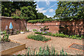
Patchworking Garden Project
Social gardening project in a former walled garden off Pixham Lane. For a period in the 1990s the site had seen temporary use as a car park by Friends Provident, while its offices on the other side of the road were being refurbished. The site later fell derelict until taken over by Patchworking who restored it to provide a place for people experiencing difficulties as a result of isolation, bereavement or recovery from either psychological or physical ill-health to take part in gardening activities.
Seen here on the day of the official opening on 11 July 2015.
Image: © Ian Capper
Taken: 11 Jul 2015
0.05 miles
5
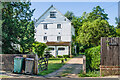
Pixham Mill
Historic mill on the Pipp Brook at Pixham, Dorking.
www.visitdorking.com
Image: © Colin Smith
Taken: 9 Aug 2012
0.05 miles
6
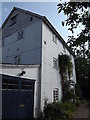
Pixham Mill
Mill building alongside the Pipp Brook, built in 1837. In its final years, up to ceasing operating in 1910, it was used by local firm Attlee's. It is now in residential use. Grade II listed - see www.historicengland.org.uk/listing/the-list/list-entry/1229433.
Image: © Ian Capper
Taken: 13 Jun 2021
0.06 miles
7
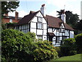
Old Cottage, Pixham
Timber-framed Surrey Building of Historic Interest in north-eastern Dorking.
www.visitdorking.com
Image: © Colin Smith
Taken: 9 Aug 2012
0.06 miles
8
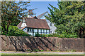
Pixham Mill Cottage
17th Century cottage adjacent to Pixham Mill (in background - see Image). Grade II listed - see www.historicengland.org.uk/listing/the-list/list-entry/1228834.
Image: © Ian Capper
Taken: 13 Jun 2021
0.06 miles
9
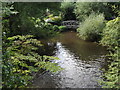
Pipp Brook, Pixham
Wide stream in Dorking, close to Pixham Mill, and to the Brook's mouth where it flows into the River Mole.
www.visitdorking.com
Image: © Colin Smith
Taken: 9 Aug 2012
0.06 miles
10

Footpath to Deepdene Station
An unusual route passing through gardens and passing a private house.
Image: © James Emmans
Taken: 9 Dec 2021
0.08 miles