IMAGES TAKEN NEAR TO
Curtis Road, DORKING, RH4 1DY
Introduction
This page details the photographs taken nearby to Curtis Road, RH4 1DY by members of the Geograph project.
The Geograph project started in 2005 with the aim of publishing, organising and preserving representative images for every square kilometre of Great Britain, Ireland and the Isle of Man.

There are currently over 7.5m images from over14,400 individuals and you can help contribute to the project by visiting https://www.geograph.org.uk
Image Map (Loading...)


Getting Data...Please wait
Leaflet Map data © OpenStreetMap
Images are licensed for reuse under creativecommons.org/licenses/by-sa/2.0
Notes
- Clicking on the map will re-center to the selected point.
- The higher the marker number, the further away the image location is from the centre of the postcode.
Image Listing (479 Images Found)
Images are licensed for reuse under creativecommons.org/licenses/by-sa/2.0
Image
Details
Distance
1
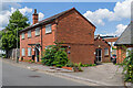
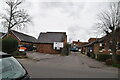
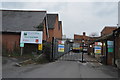
Newrella House
Building in Curtis Road, now part of the Old Water Yard light business/industrial area.
Image: © Ian Capper
Taken: 3 Aug 2021
0.01 miles
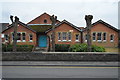
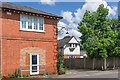
3
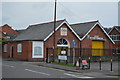
Unit 1, The Old Water Yard
Building in Curtis Road, now part of the Old Water Yard light business/industrial area.
Image: © Ian Capper
Taken: 3 Aug 2021
0.01 miles
8
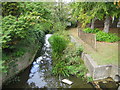
Pipp Brook in Dorking
Viewed looking upstream from the Station Road bridge.
Image: © Nigel Cox
Taken: 20 Sep 2006
0.02 miles
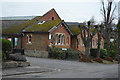
9
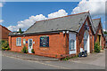
Communications House and Electricity Cottage
Buildings in Curtis Road, now part of a Mole Valley District Council depot.
Image: © Ian Capper
Taken: 3 Aug 2021
0.02 miles