IMAGES TAKEN NEAR TO
Church Street, DORKING, RH4 1DW
Introduction
This page details the photographs taken nearby to Church Street, RH4 1DW by members of the Geograph project.
The Geograph project started in 2005 with the aim of publishing, organising and preserving representative images for every square kilometre of Great Britain, Ireland and the Isle of Man.

There are currently over 7.5m images from over14,400 individuals and you can help contribute to the project by visiting https://www.geograph.org.uk
Image Map
Images are licensed for reuse under creativecommons.org/licenses/by-sa/2.0
Notes
- Clicking on the map will re-center to the selected point.
- The higher the marker number, the further away the image location is from the centre of the postcode.
Image Listing (643 Images Found)
Images are licensed for reuse under creativecommons.org/licenses/by-sa/2.0
Image
Details
Distance
1
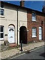
Looking across Church Street towards Archway Place
Image: © Basher Eyre
Taken: 24 Jul 2013
0.00 miles
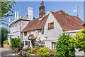
2
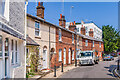
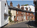
Church Street
Terrace of cottages in Church Street dating from the 1820s.
Image: © Ian Capper
Taken: 22 Jul 2021
0.00 miles
3
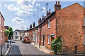
Church Street
Terrace of cottages in Church Street dating from the 1820s.
Image: © Ian Capper
Taken: 22 Jul 2021
0.01 miles
4
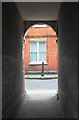
View into Church Street, Dorking, from Archway Place
Archway Place is a narrow passageway - what in Lincolnshire or Leicestershire would be called a jitty, in Nottingham a twitchel http://www.geograph.org.uk/photo/1720369, in parts of the south a twitten http://www.geograph.org.uk/photo/1260680.
Image: © Stefan Czapski
Taken: 11 Jan 2012
0.01 miles
5
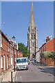
Church Street
Looking along Church Street to St Martin's Church.
Image: © Ian Capper
Taken: 22 Jul 2021
0.01 miles
6
Church Street, Dorking
Looking east along Church Street from the junction with North Street.
Image: © Alan Hunt
Taken: 20 Apr 2015
0.01 miles
7
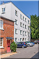
Church Court
Apartment block in Church Street adjacent to St Martin's Church, dating from the first half of the 20th Century, originally named Stane Court.
Image: © Ian Capper
Taken: 22 Jul 2021
0.01 miles
8
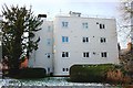
Church Court, Church Street
This four storey block of flats may be uncompromisingly located next to St Martin's church, but the curved exterior wall does offer some hint of art deco.
Image: © Hugh Craddock
Taken: 26 Dec 2010
0.02 miles
9
Leslie House and Leslie Cottage
Pair of houses in North Street. Leslie House, on the left, has a date plaque of 1838 on its rear gable and Leslie Cottage in 17th Century. Both are grade II listed - see www.historicengland.org.uk/listing/the-list/list-entry/1378064 and www.historicengland.org.uk/listing/the-list/list-entry/1216529 respectively.
Image: © Ian Capper
Taken: 22 Jul 2021
0.02 miles
10
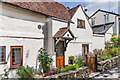
Leslie Cottage
17th Century cottage in North Street. Grade II listed - see www.historicengland.org.uk/listing/the-list/list-entry/1216529.
Image: © Ian Capper
Taken: 22 Jul 2021
0.02 miles