IMAGES TAKEN NEAR TO
Archway Mews, DORKING, RH4 1BX
Introduction
This page details the photographs taken nearby to Archway Mews, RH4 1BX by members of the Geograph project.
The Geograph project started in 2005 with the aim of publishing, organising and preserving representative images for every square kilometre of Great Britain, Ireland and the Isle of Man.

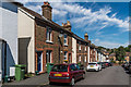
There are currently over 7.5m images from over14,400 individuals and you can help contribute to the project by visiting https://www.geograph.org.uk
Image Map (Loading...)


Getting Data...Please wait
Leaflet Map data © OpenStreetMap
Images are licensed for reuse under creativecommons.org/licenses/by-sa/2.0
Notes
- Clicking on the map will re-center to the selected point.
- The higher the marker number, the further away the image location is from the centre of the postcode.
Image Listing (632 Images Found)
Images are licensed for reuse under creativecommons.org/licenses/by-sa/2.0
Image
Details
Distance
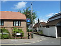
1
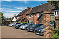
Archway Place
Late 20th Century development off St Martin's Walk car park.
Image: © Ian Capper
Taken: 11 Aug 2017
0.02 miles
2
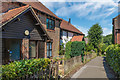
Chapel Court
Footpath connecting Church Street with Meadowbank, with part of Chapel Court on the left and of Archway Place on the right.
Image: © Ian Capper
Taken: 11 Aug 2017
0.03 miles
3
Archway Place
Late 20th Century development off St Martin's Walk car park.
Image: © Ian Capper
Taken: 22 Jul 2021
0.03 miles
4
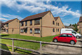
Willow Mead
Late 20th Century development north of Pippbrook. All the blocks are named after birds associated with water - in the centre is Mallard Court and on the left is Kingfisher Court.
Image: © Ian Capper
Taken: 11 Aug 2017
0.03 miles
5
Meadowbrook Road
Late Victorian terraced housing in a street running from Church Street down to the Pippbrook.
Image: © Ian Capper
Taken: 11 Aug 2017
0.04 miles
6
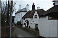
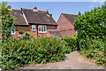
Lesley Cottage
Grade II listed. http://www.britishlistedbuildings.co.uk/en-289874-lesley-cottage-surrey
Image: © N Chadwick
Taken: 6 Feb 2016
0.06 miles
7
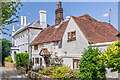
Leslie House and Leslie Cottage
Pair of houses in North Street. Leslie House, on the left, has a date plaque of 1838 on its rear gable and Leslie Cottage in 17th Century. Both are grade II listed - see www.historicengland.org.uk/listing/the-list/list-entry/1378064 and www.historicengland.org.uk/listing/the-list/list-entry/1216529 respectively.
Image: © Ian Capper
Taken: 22 Jul 2021
0.06 miles
8
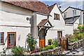
Leslie Cottage
17th Century cottage in North Street. Grade II listed - see www.historicengland.org.uk/listing/the-list/list-entry/1216529.
Image: © Ian Capper
Taken: 22 Jul 2021
0.06 miles
9
Road and path junction in Church Street
Image: © Basher Eyre
Taken: 24 Jul 2013
0.06 miles
10
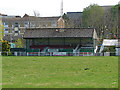
Dorking football ground
The Meadowbank Stadium, currently out of use due to safety concerns, the former home ground of Dorking Football Club. The club are using the Horley FC ground for home games until this stadium is re-instated. Dorking FC are one of the oldest clubs in Surrey and play in the Combined Counties League.
Image: © Alan Hunt
Taken: 20 Apr 2015
0.06 miles