IMAGES TAKEN NEAR TO
High Street, DORKING, RH4 1AZ
Introduction
This page details the photographs taken nearby to High Street, RH4 1AZ by members of the Geograph project.
The Geograph project started in 2005 with the aim of publishing, organising and preserving representative images for every square kilometre of Great Britain, Ireland and the Isle of Man.

There are currently over 7.5m images from over14,400 individuals and you can help contribute to the project by visiting https://www.geograph.org.uk
Image Map
Images are licensed for reuse under creativecommons.org/licenses/by-sa/2.0
Notes
- Clicking on the map will re-center to the selected point.
- The higher the marker number, the further away the image location is from the centre of the postcode.
Image Listing (629 Images Found)
Images are licensed for reuse under creativecommons.org/licenses/by-sa/2.0
Image
Details
Distance
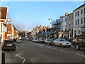
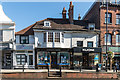
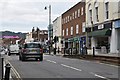
2
90 - 106 High Street
Buildings on High Street.
That on the right, nos 90 - 98 (with the far right section slightly recessed and brick faced) dates from the 18th Century and that on the left, nos 100 - 106, from the late 18th/early 19th Century. Both are grade II listed - see www.historicengland.org.uk/listing/the-list/list-entry/1378089 and www.historicengland.org.uk/listing/the-list/list-entry/1028858 respectively.
The bollards in front are separately grade II listed - see www.historicengland.org.uk/listing/the-list/list-entry/1378090.
Image: © Ian Capper
Taken: 1 Sep 2018
0.01 miles
3
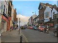
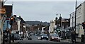
Dorking High Street
With Box Hill in the background
Image: © Paul Gillett
Taken: 19 Nov 2011
0.02 miles
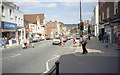
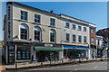
7
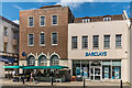
87-99 High Street
Barclays Bank branch on High Street. The stall on the left is the Food Float, a not-for-profit community market stall showcasing Mole Valley produce which has operated on the pavement here since around 2010.
Image: © Ian Capper
Taken: 11 Aug 2017
0.02 miles
8
74 - 82 High Street
Building on High Street.
The bollards in front are grade II listed - see www.historicengland.org.uk/listing/the-list/list-entry/1378090.
Image: © Ian Capper
Taken: 1 Sep 2018
0.02 miles
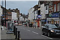
10
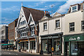
101-105 and 111-117 High Street
111-117 High Street, the stuccoed building towards the right of the photo, housing the clothung retailer Fat Face, dates from the early to mid 19th Century and is grade II listed - see www.historicengland.org.uk/listing/the-list/list-entry/1028868.
Image: © Ian Capper
Taken: 11 Aug 2017
0.03 miles