IMAGES TAKEN NEAR TO
Mill Hill Lane, BETCHWORTH, RH3 7LR
Introduction
This page details the photographs taken nearby to Mill Hill Lane, RH3 7LR by members of the Geograph project.
The Geograph project started in 2005 with the aim of publishing, organising and preserving representative images for every square kilometre of Great Britain, Ireland and the Isle of Man.

There are currently over 7.5m images from over14,400 individuals and you can help contribute to the project by visiting https://www.geograph.org.uk
Image Map
Images are licensed for reuse under creativecommons.org/licenses/by-sa/2.0
Notes
- Clicking on the map will re-center to the selected point.
- The higher the marker number, the further away the image location is from the centre of the postcode.
Image Listing (33 Images Found)
Images are licensed for reuse under creativecommons.org/licenses/by-sa/2.0
Image
Details
Distance
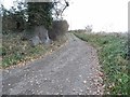
1
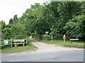
Mill Hill Lane
Mill Hill Lane looking north, at the junction with Kiln Lane. Mill Hill Lane is a public bridleway, Brockham 52.
Image: © Hugh Craddock
Taken: 22 Jun 2008
0.08 miles
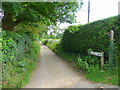
2
Mill Hill Lane at the junction of Kiln Lane
Image: © David Howard
Taken: 22 Sep 2014
0.10 miles
3
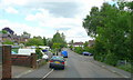
Nutwood Avenue
A small estate to the east of Brockham.
Image: © Jonathan Billinger
Taken: 19 Jun 2008
0.12 miles
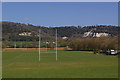
5

Brockham
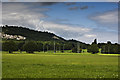
The village of Brockham seen from the top of Brockham Quarry. At the foot of the photo is the Big Field, a National Trust owned area of land used by Dorking Rugby Club, its ownership protecting it from development. In the centre of the photo is the spire of Christ Church.
Image: © Ian Capper
Taken: 30 Jun 2012
0.17 miles
6
Mill Hill Lane
Forms part of a footpath link between the North Downs Way and the Greensand Way as it leads to a footbridge over the River Mole between Betchworth and Brockham.
Image: © Jonathan Billinger
Taken: 19 Jun 2008
0.17 miles
7
Big Field
Brockham Big Field is owned by the National Trust, who acquired the freehold in 1966. It is leased to Dorking Rugby Club and Mole Valley District Council for sports use. In the background are the former Brockham Quarries.
Image: © Ian Capper
Taken: 17 Apr 2010
0.18 miles
8
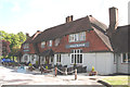
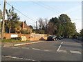
Betchworth: The 'Arkle Manor'
Named in honour of the famous steeplechaser. This horse has its own marked grave on the Downs nearby.
Image: © Dr Neil Clifton
Taken: 9 Aug 2013
0.18 miles
9
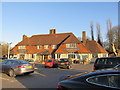
The Arkle Manor Public House
A 'Country Pub', it can be found near Betchworth on the A25
Image: © Richard Rogerson
Taken: 15 Jan 2012
0.18 miles